Telgte night lights from space
Night Light of Telgte (North Rhine-Westphalia) from space (Germany) Src. Average luminocity for 10x10km area is 1.8018% and for 50x50km: 5.3838%.
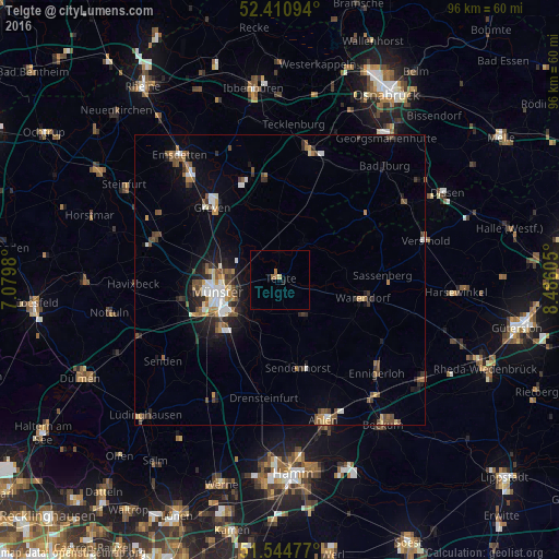
Analysis of Telgte night lights 2016
Square area 10x10 km:
 0%
0%90-99
0%80-89
0.51%70-79
0%60-69
1.14%50-59
0.38%40-49
0%30-39
0%20-29
0%10-19
0.51%0-9
97.47%Square area 50x50 km:
0.64%90-99
0.84%80-89
0.34%70-79
0.53%60-69
0.78%50-59
0.89%40-49
1.15%30-39
0.7%20-29
1.16%10-19
3.1%0-9
89.86%Clear (daylight) street map image can be seen on geolist.org.
Map coordinates:
52° 24' 39.4" North, 7° 4' 47.3" East
51° 58' 47.8" North, 7° 46' 58.5" East
51° 32' 41.2" North, 8° 29' 9.8" East
Some cities around Telgte sort by population:
• Münster
10.9 km =6.8 mi,  259°
259°
• Warendorf
14.4 km =8.9 mi,  102°
102°
• Greven
18.1 km =11.2 mi,  314°
314°
• Sassenberg
17.7 km =11 mi,  85°
85°
• Sendenhorst
15.6 km =9.7 mi,  168°
168°
• Ostbevern
7.8 km =4.8 mi,  31°
31°
• Everswinkel
7.4 km =4.6 mi,  143°
143°
• Ladbergen
17.2 km =10.7 mi,  352°
352°
2823590 (p: 19,389)
Sources (retrieved 2019-11-25):
» Earth at Night: Flat Maps 2012, 2016