Tangerhütte night lights from space
Night Light of Tangerhütte (Saxony-Anhalt) from space (Germany) Src. Average luminocity for 10x10km area is 1.0808% and for 50x50km: 1.8375%.
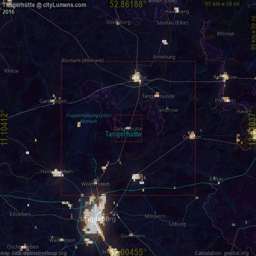
Analysis of Tangerhütte night lights 2016
Square area 10x10 km:
 0%
0%90-99
0%80-89
0%70-79
0.51%60-69
0%50-59
1.01%40-49
0%30-39
0%20-29
0%10-19
0%0-9
98.48%Square area 50x50 km:
0.25%90-99
0.28%80-89
0.17%70-79
0.29%60-69
0.19%50-59
0.21%40-49
0.24%30-39
0.06%20-29
0.16%10-19
0.85%0-9
97.31%Clear (daylight) street map image can be seen on geolist.org.
Map coordinates:
52° 51' 42.8" North, 11° 6' 14.8" East
52° 26' 7.1" North, 11° 48' 26.1" East
52° 0' 16.4" North, 12° 30' 37.3" East
Some cities around Tangerhütte sort by population:
• Neue Neustadt
33.9 km =21.1 mi,  200°
200°
• Stendal
19.4 km =12.1 mi,  10°
10°
• Burg bei Magdeburg
18.5 km =11.5 mi,  169°
169°
• Haldensleben I
31.5 km =19.6 mi,  238°
238°
• Genthin
24.1 km =15 mi,  97°
97°
• Gardelegen
29.6 km =18.4 mi,  289°
289°
• Wolmirstedt
24 km =14.9 mi,  210°
210°
• Barleben
29 km =18 mi, 206°
2824255 (p: 6,039)
Sources (retrieved 2019-11-25):
» Earth at Night: Flat Maps 2012, 2016