Stockach night lights from space
Night Light of Stockach (Baden-Württemberg) from space (Germany) Src. Average luminocity for 10x10km area is 2.5739% and for 50x50km: 4.1942%.
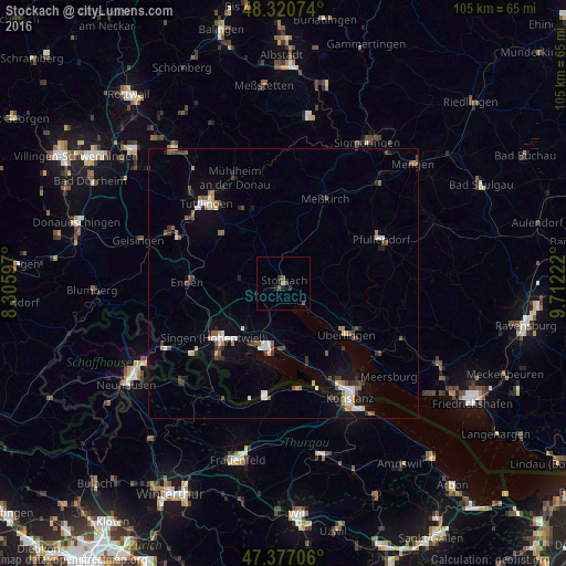
Analysis of Stockach night lights 2016
Square area 10x10 km:
 0%
0%90-99
0%80-89
0%70-79
0%60-69
0.57%50-59
1.42%40-49
0.28%30-39
1.56%20-29
0.71%10-19
1.56%0-9
93.89%Square area 50x50 km:
0.51%90-99
0.7%80-89
0.24%70-79
0.31%60-69
0.49%50-59
0.66%40-49
0.65%30-39
0.76%20-29
0.62%10-19
2.13%0-9
92.94%Clear (daylight) street map image can be seen on geolist.org.
Map coordinates:
48° 19' 14.7" North, 8° 18' 21.5" East
47° 51' 3.8" North, 9° 0' 32.8" East
47° 22' 37.4" North, 9° 42' 44" East
Some cities around Stockach sort by population:
• Singen
16.2 km =10.1 mi,  231°
231°
• Radolfzell
12.5 km =7.8 mi,  193°
193°
• Überlingen
15.1 km =9.4 mi,  126°
126°
• Rielasingen-Worblingen
18.1 km =11.2 mi,  224°
224°
• Engen
17.6 km =10.9 mi,  271°
271°
• Meßkirch
17.8 km =11.1 mi,  26°
26°
• Allensbach
15.8 km =9.8 mi,  162°
162°
• Reichenau
18.5 km =11.5 mi,  167°
167°
2826909 (p: 16,844)
Sources (retrieved 2019-11-25):
» Earth at Night: Flat Maps 2012, 2016