Neuenhagen night lights from space
Night Light of Neuenhagen (Brandenburg) from space (Germany) Src. Average luminocity for 10x10km area is 34.213% and for 50x50km: 24.7699%.
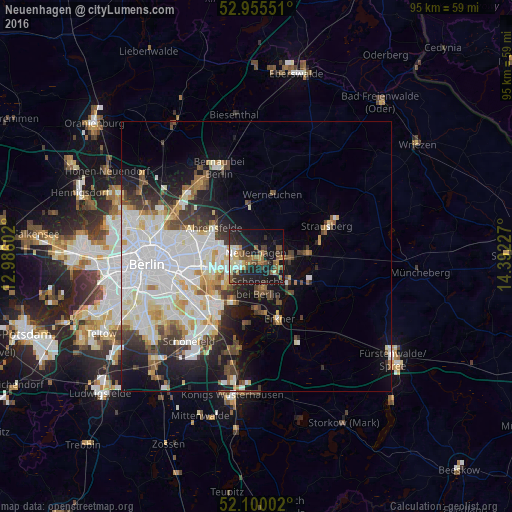
Analysis of Neuenhagen night lights 2016
Square area 10x10 km:
 2.65%
2.65%90-99
5.03%80-89
4.37%70-79
2.65%60-69
7.41%50-59
6.75%40-49
5.42%30-39
5.29%20-29
11.9%10-19
34.13%0-9
14.42%Square area 50x50 km:
7.84%90-99
6.35%80-89
2.38%70-79
1.85%60-69
1.79%50-59
2.12%40-49
2.7%30-39
2.76%20-29
3.86%10-19
8.84%0-9
59.52%Clear (daylight) street map image can be seen on geolist.org.
Map coordinates:
52° 57' 19.8" North, 12° 59' 9.7" East
52° 31' 47.5" North, 13° 41' 20.9" East
52° 6' 0.1" North, 14° 23' 32.2" East
Some cities around Neuenhagen sort by population:
• Marzahn
8.2 km =5.1 mi,  281°
281°
• Hellersdorf
5.4 km =3.4 mi,  273°
273°
• Mahlsdorf
5.6 km =3.5 mi,  245°
245°
• Kaulsdorf
6.9 km =4.3 mi,  258°
258°
• Petershagen
6.7 km =4.2 mi,  98°
98°
• Schöneiche
6.3 km =3.9 mi,  178°
178°
• Altlandsberg
4.7 km =2.9 mi,  33°
33°
• Woltersdorf
9.2 km =5.7 mi,  153°
153°
2865716 (p: 16,170)
Sources (retrieved 2019-11-25):
» Earth at Night: Flat Maps 2012, 2016