Königstein im Taunus night lights from space
Night Light of Königstein im Taunus (Hesse) from space (Germany) Src. Average luminocity for 10x10km area is 28.635% and for 50x50km: 28.1307%.
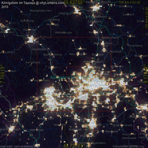
Analysis of Königstein im Taunus night lights 2016
Square area 10x10 km:
 3.88%
3.88%90-99
2.54%80-89
2.14%70-79
5.88%60-69
4.01%50-59
5.08%40-49
4.01%30-39
4.14%20-29
13.5%10-19
18.45%0-9
36.36%Square area 50x50 km:
6.73%90-99
6.33%80-89
2.54%70-79
2.42%60-69
2.87%50-59
2.58%40-49
3.9%30-39
5.29%20-29
8.58%10-19
10.44%0-9
48.32%Clear (daylight) street map image can be seen on geolist.org.
Map coordinates:
50° 37' 39.3" North, 7° 46' 5.5" East
50° 10' 45.9" North, 8° 28' 16.8" East
49° 43' 37.3" North, 9° 10' 28" East
Some cities around Königstein im Taunus sort by population:
• Kelkheim (Taunus)
4.9 km =3 mi,  197°
197°
• Bad Soden am Taunus
4.9 km =3 mi,  151°
151°
• Kronberg
3.7 km =2.3 mi,  81°
81°
• Kronberg Tal
2.3 km =1.4 mi,  90°
90°
• Schwalbach am Taunus
5.5 km =3.4 mi,  126°
126°
• Liederbach
6.6 km =4.1 mi,  165°
165°
• Sulzbach
6.5 km =4 mi,  141°
141°
• Glashütten
6.6 km =4.1 mi,  309°
309°
2885760 (p: 15,661)
Sources (retrieved 2019-11-25):
» Earth at Night: Flat Maps 2012, 2016