Sankt Johann night lights from space
Night Light of Sankt Johann (Baden-Württemberg) from space (Germany) Src. Average luminocity for 10x10km area is 1.8054% and for 50x50km: 8.3837%.
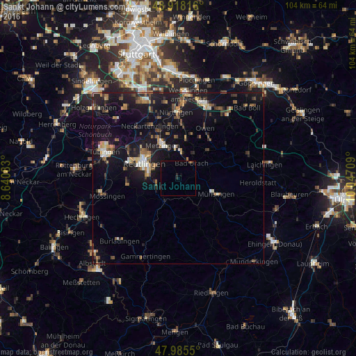
Analysis of Sankt Johann night lights 2016
Square area 10x10 km:
 0%
0%90-99
0%80-89
0%70-79
0%60-69
0.57%50-59
0.43%40-49
0.14%30-39
0%20-29
1.14%10-19
0.57%0-9
97.16%Square area 50x50 km:
0.55%90-99
0.97%80-89
0.77%70-79
0.77%60-69
1.36%50-59
1.33%40-49
1.23%30-39
1.28%20-29
2.02%10-19
11.08%0-9
78.65%Clear (daylight) street map image can be seen on geolist.org.
Map coordinates:
48° 55' 5.4" North, 8° 38' 27" East
48° 27' 14.3" North, 9° 20' 38.3" East
47° 59' 7.8" North, 10° 2' 49.5" East
Some cities around Sankt Johann sort by population:
• Reutlingen
11.1 km =6.9 mi,  292°
292°
• Metzingen
10.3 km =6.4 mi,  334°
334°
• Pfullingen
8.6 km =5.3 mi,  277°
277°
• Bad Urach
5.8 km =3.6 mi,  45°
45°
• Eningen unter Achalm
7.2 km =4.5 mi,  300°
300°
• Dettingen an der Erms
8.5 km =5.3 mi,  0°
0°
• Unterhausen
7.1 km =4.4 mi,  247°
247°
• Neuffen
11.4 km =7.1 mi,  11°
11°
2841577 (p: 5,181)
Sources (retrieved 2019-11-25):
» Earth at Night: Flat Maps 2012, 2016