Ruhla night lights from space
Night Light of Ruhla (Thuringia) from space (Germany) Src. Average luminocity for 10x10km area is 0.8627% and for 50x50km: 2.3932%.
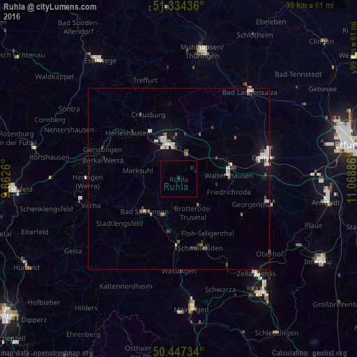
Analysis of Ruhla night lights 2016
Square area 10x10 km:
 0%
0%90-99
0%80-89
0%70-79
0%60-69
0%50-59
0%40-49
0%30-39
0%20-29
1.12%10-19
1.12%0-9
97.76%Square area 50x50 km:
0.41%90-99
0.53%80-89
0.14%70-79
0.13%60-69
0.24%50-59
0.28%40-49
0.34%30-39
0.23%20-29
0.37%10-19
1.42%0-9
95.91%Clear (daylight) street map image can be seen on geolist.org.
Map coordinates:
51° 20' 3.7" North, 9° 39' 45.4" East
50° 53' 34.7" North, 10° 21' 56.6" East
50° 26' 50.4" North, 11° 4' 7.9" East
Some cities around Ruhla sort by population:
• Gotha
24.4 km =15.2 mi,  75°
75°
• Eisenach
10.4 km =6.5 mi,  340°
340°
• Schmalkalden
19.9 km =12.4 mi,  163°
163°
• Bad Salzungen
12.7 km =7.9 mi,  225°
225°
• Waltershausen
13.5 km =8.4 mi,  87°
87°
• Heringen
25.2 km =15.7 mi,  268°
268°
• Friedrichroda
14.5 km =9 mi,  105°
105°
• Breitungen
14.6 km =9.1 mi,  190°
190°
2843258 (p: 6,757)
Sources (retrieved 2019-11-25):
» Earth at Night: Flat Maps 2012, 2016