Reichenbach an der Fils night lights from space
Night Light of Reichenbach an der Fils (Baden-Württemberg) from space (Germany) Src. Average luminocity for 10x10km area is 15.7768% and for 50x50km: 22.612%.
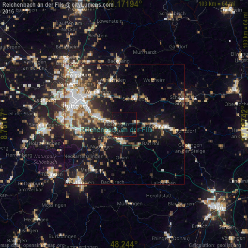
Analysis of Reichenbach an der Fils night lights 2016
Square area 10x10 km:
 0.89%
0.89%90-99
2.08%80-89
1.19%70-79
0.89%60-69
1.34%50-59
1.49%40-49
2.83%30-39
2.68%20-29
1.93%10-19
27.98%0-9
56.7%Square area 50x50 km:
3.71%90-99
4.11%80-89
1.89%70-79
2.47%60-69
3.33%50-59
3.19%40-49
3.58%30-39
3.4%20-29
5.01%10-19
14.85%0-9
54.46%Clear (daylight) street map image can be seen on geolist.org.
Map coordinates:
49° 10' 19" North, 8° 45' 40.2" East
48° 42' 36.4" North, 9° 27' 51.4" East
48° 14' 38.4" North, 10° 10' 2.7" East
Some cities around Reichenbach an der Fils sort by population:
• Kirchheim unter Teck
7.1 km =4.4 mi,  186°
186°
• Ebersbach an der Fils
4.4 km =2.7 mi,  81°
81°
• Wendlingen am Neckar
7.8 km =4.8 mi,  236°
236°
• Plochingen
3.3 km =2.1 mi,  271°
271°
• Wernau
4.1 km =2.5 mi, 242°
• Deizisau
5.7 km =3.5 mi, 272°
• Altbach
6.3 km =3.9 mi,  282°
282°
• Baltmannsweiler
3.7 km =2.3 mi,  342°
342°
2849118 (p: 8,046)
Sources (retrieved 2019-11-25):
» Earth at Night: Flat Maps 2012, 2016