Baltmannsweiler night lights from space
Night Light of Baltmannsweiler (Baden-Württemberg) from space (Germany) Src. Average luminocity for 10x10km area is 12.1994% and for 50x50km: 23.5495%.
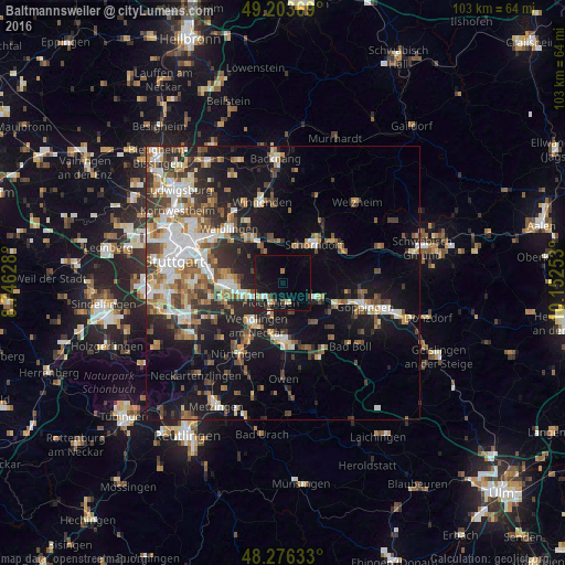
Analysis of Baltmannsweiler night lights 2016
Square area 10x10 km:
 0.74%
0.74%90-99
1.19%80-89
1.34%70-79
1.19%60-69
1.04%50-59
0.89%40-49
1.64%30-39
1.19%20-29
2.53%10-19
15.77%0-9
72.47%Square area 50x50 km:
3.82%90-99
4.27%80-89
1.99%70-79
2.53%60-69
3.5%50-59
3.29%40-49
3.79%30-39
3.79%20-29
5.61%10-19
14.77%0-9
52.62%Clear (daylight) street map image can be seen on geolist.org.
Map coordinates:
49° 12' 13.3" North, 8° 44' 46.6" East
48° 44' 31.7" North, 9° 26' 57.8" East
48° 16' 34.8" North, 10° 9' 9.1" East
Some cities around Baltmannsweiler sort by population:
• Ebersbach an der Fils
6.2 km =3.9 mi,  118°
118°
• Plochingen
4.1 km =2.5 mi,  212°
212°
• Wernau
6 km =3.7 mi,  204°
204°
• Köngen
8.9 km =5.5 mi,  222°
222°
• Reichenbach an der Fils
3.7 km =2.3 mi,  162°
162°
• Winterbach
6.7 km =4.2 mi,  18°
18°
• Deizisau
5.7 km =3.5 mi,  234°
234°
• Altbach
5.5 km =3.4 mi,  246°
246°
2953008 (p: 5,584)
Sources (retrieved 2019-11-25):
» Earth at Night: Flat Maps 2012, 2016