Altbach night lights from space
Night Light of Altbach (Baden-Württemberg) from space (Germany) Src. Average luminocity for 10x10km area is 34.5238% and for 50x50km: 25.9607%.
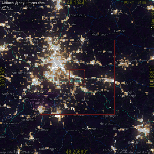
Analysis of Altbach night lights 2016
Square area 10x10 km:
 5.06%
5.06%90-99
5.95%80-89
1.64%70-79
6.1%60-69
4.17%50-59
1.04%40-49
5.21%30-39
4.17%20-29
24.11%10-19
27.83%0-9
14.73%Square area 50x50 km:
4.2%90-99
4.86%80-89
2.15%70-79
2.87%60-69
3.82%50-59
3.4%40-49
3.89%30-39
4.19%20-29
7.59%10-19
16.83%0-9
46.2%Clear (daylight) street map image can be seen on geolist.org.
Map coordinates:
49° 11' 3.8" North, 8° 40' 39.5" East
48° 43' 21.6" North, 9° 22' 50.8" East
48° 15' 24.1" North, 10° 5' 2.1" East
Some cities around Altbach sort by population:
• Esslingen
5.9 km =3.7 mi,  288°
288°
• Wendlingen am Neckar
5.7 km =3.5 mi,  183°
183°
• Plochingen
3.1 km =1.9 mi,  115°
115°
• Wernau
4.2 km =2.6 mi,  142°
142°
• Denkendorf
5.6 km =3.5 mi,  237°
237°
• Köngen
4.5 km =2.8 mi,  193°
193°
• Deizisau
1.2 km =0.7 mi,  161°
161°
• Baltmannsweiler
5.5 km =3.4 mi,  66°
66°
2958085 (p: 5,793)
Sources (retrieved 2019-11-25):
» Earth at Night: Flat Maps 2012, 2016