Planegg night lights from space
Night Light of Planegg (Bavaria) from space (Germany) Src. Average luminocity for 10x10km area is 46.6384% and for 50x50km: 19.065%.
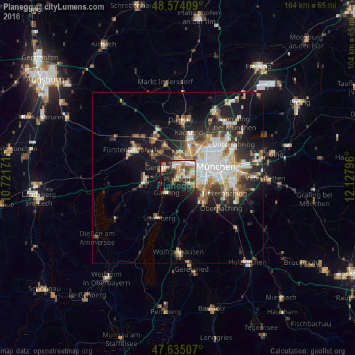
Analysis of Planegg night lights 2016
Square area 10x10 km:
 5.95%
5.95%90-99
12.5%80-89
3.57%70-79
5.65%60-69
7.44%50-59
7.74%40-49
5.65%30-39
6.55%20-29
16.96%10-19
22.92%0-9
5.06%Square area 50x50 km:
3.93%90-99
3.87%80-89
1.93%70-79
1.85%60-69
2.35%50-59
2.47%40-49
2.18%30-39
2.7%20-29
5.04%10-19
10.7%0-9
62.99%Clear (daylight) street map image can be seen on geolist.org.
Map coordinates:
48° 34' 26.7" North, 10° 43' 18.2" East
48° 6' 24.2" North, 11° 25' 29.4" East
47° 38' 6.3" North, 12° 7' 40.7" East
Some cities around Planegg sort by population:
• Germering
4.7 km =2.9 mi,  310°
310°
• Pasing
4.5 km =2.8 mi,  30°
30°
• Puchheim
7.3 km =4.5 mi, 310°
• Gauting
5.5 km =3.4 mi,  220°
220°
• Gräfelfing
1.4 km =0.9 mi,  14°
14°
• Pullach im Isartal
8.8 km =5.5 mi,  125°
125°
• Krailling
2 km =1.2 mi,  247°
247°
• Neuried
3.4 km =2.1 mi,  116°
116°
2853463 (p: 10,510)
Sources (retrieved 2019-11-25):
» Earth at Night: Flat Maps 2012, 2016