Neuried night lights from space
Night Light of Neuried (Bavaria) from space (Germany) Src. Average luminocity for 10x10km area is 53.0223% and for 50x50km: 19.5594%.
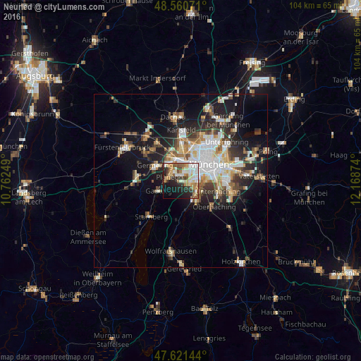
Analysis of Neuried night lights 2016
Square area 10x10 km:
 9.97%
9.97%90-99
12.65%80-89
7.29%70-79
6.55%60-69
9.67%50-59
6.25%40-49
4.46%30-39
5.8%20-29
15.18%10-19
14.58%0-9
7.59%Square area 50x50 km:
3.95%90-99
3.91%80-89
1.96%70-79
1.93%60-69
2.41%50-59
2.57%40-49
2.3%30-39
2.81%20-29
5.18%10-19
11.24%0-9
61.75%Clear (daylight) street map image can be seen on geolist.org.
Map coordinates:
48° 33' 38.6" North, 10° 45' 45" East
48° 5' 35.6" North, 11° 27' 56.2" East
47° 37' 17.2" North, 12° 10' 7.5" East
Some cities around Neuried sort by population:
• Germering
8 km =5 mi,  304°
304°
• Pasing
5.4 km =3.4 mi,  352°
352°
• Gauting
7.1 km =4.4 mi,  247°
247°
• Gräfelfing
3.9 km =2.4 mi,  316°
316°
• Grünwald
7.4 km =4.6 mi,  144°
144°
• Planegg
3.4 km =2.1 mi, 296°
• Pullach im Isartal
5.5 km =3.4 mi,  130°
130°
• Krailling
4.9 km =3 mi,  278°
278°
2864303 (p: 7,469)
Sources (retrieved 2019-11-25):
» Earth at Night: Flat Maps 2012, 2016