Puchheim night lights from space
Night Light of Puchheim (Bavaria) from space (Germany) Src. Average luminocity for 10x10km area is 29.8185% and for 50x50km: 17.2068%.
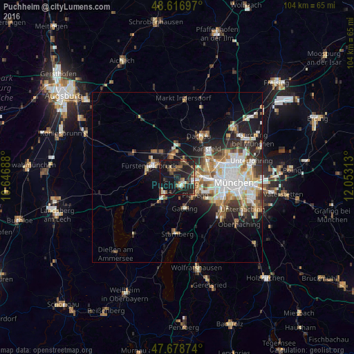
Analysis of Puchheim night lights 2016
Square area 10x10 km:
 1.79%
1.79%90-99
3.27%80-89
2.53%70-79
1.79%60-69
4.61%50-59
3.87%40-49
7.59%30-39
5.8%20-29
18.3%10-19
46.43%0-9
4.02%Square area 50x50 km:
3.72%90-99
3.53%80-89
1.76%70-79
1.74%60-69
2.15%50-59
2.26%40-49
1.92%30-39
2.45%20-29
4.08%10-19
8.8%0-9
67.59%Clear (daylight) street map image can be seen on geolist.org.
Map coordinates:
48° 37' 1.1" North, 10° 38' 48.8" East
48° 9' 0" North, 11° 21' 0" East
47° 40' 43.5" North, 12° 3' 11.3" East
Some cities around Puchheim sort by population:
• Germering
2.7 km =1.7 mi,  132°
132°
• Olching
5.7 km =3.5 mi,  347°
347°
• Gröbenzell
5.7 km =3.5 mi,  12°
12°
• Gilching
6.3 km =3.9 mi,  221°
221°
• Gräfelfing
6.8 km =4.2 mi,  120°
120°
• Eichenau
3.1 km =1.9 mi,  306°
306°
• Krailling
6.7 km =4.2 mi,  146°
146°
• Emmering
6.2 km =3.9 mi, 306°
2851782 (p: 19,357)
Sources (retrieved 2019-11-25):
» Earth at Night: Flat Maps 2012, 2016