Oettingen in Bayern night lights from space
Night Light of Oettingen in Bayern (Bavaria) from space (Germany) Src. Average luminocity for 10x10km area is 2.8168% and for 50x50km: 1.3439%.
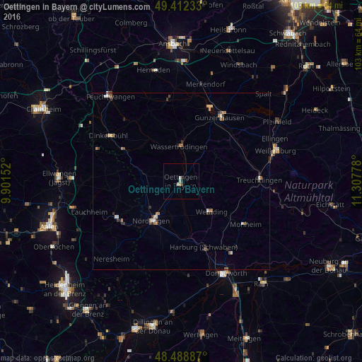
Analysis of Oettingen in Bayern night lights 2016
Square area 10x10 km:
 0%
0%90-99
0.99%80-89
0.71%70-79
0.43%60-69
0.14%50-59
0%40-49
0%30-39
0.71%20-29
0.99%10-19
0%0-9
96.02%Square area 50x50 km:
0.11%90-99
0.21%80-89
0.15%70-79
0.16%60-69
0.24%50-59
0.25%40-49
0.11%30-39
0.34%20-29
0.28%10-19
0.14%0-9
98.02%Clear (daylight) street map image can be seen on geolist.org.
Map coordinates:
49° 24' 44.4" North, 9° 54' 5.5" East
48° 57' 9.9" North, 10° 36' 16.7" East
48° 29' 19.9" North, 11° 18' 28" East
Some cities around Oettingen in Bayern sort by population:
• Nördlingen
14.1 km =8.8 mi,  216°
216°
• Gunzenhausen
21.4 km =13.3 mi,  31°
31°
• Treuchtlingen
22.2 km =13.8 mi,  89°
89°
• Bopfingen
21.1 km =13.1 mi,  240°
240°
• Dinkelsbühl
24.5 km =15.2 mi,  301°
301°
• Wassertrüdingen
10.1 km =6.3 mi,  357°
357°
• Harburg
19.5 km =12.1 mi,  161°
161°
• Wemding
12.3 km =7.6 mi,  134°
134°
2857847 (p: 5,336)
Sources (retrieved 2019-11-25):
» Earth at Night: Flat Maps 2012, 2016