Dinkelsbühl night lights from space
Night Light of Dinkelsbühl (Bavaria) from space (Germany) Src. Average luminocity for 10x10km area is 3.3973% and for 50x50km: 2.8268%.
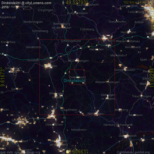
Analysis of Dinkelsbühl night lights 2016
Square area 10x10 km:
 0%
0%90-99
0%80-89
0.6%70-79
1.19%60-69
0.6%50-59
0.6%40-49
0.89%30-39
0.89%20-29
0.6%10-19
0%0-9
94.64%Square area 50x50 km:
0.27%90-99
0.46%80-89
0.3%70-79
0.4%60-69
0.39%50-59
0.3%40-49
0.38%30-39
0.42%20-29
0.32%10-19
1.3%0-9
95.45%Clear (daylight) street map image can be seen on geolist.org.
Map coordinates:
49° 31' 40.5" North, 9° 37' 0.2" East
49° 4' 9.9" North, 10° 19' 11.5" East
48° 36' 23.9" North, 11° 1' 22.7" East
Some cities around Dinkelsbühl sort by population:
• Crailsheim
19.4 km =12.1 mi,  291°
291°
• Ellwangen
18.2 km =11.3 mi,  228°
228°
• Bopfingen
23.6 km =14.7 mi,  173°
173°
• Feuchtwangen
10.5 km =6.5 mi,  7°
7°
• Herrieden
23 km =14.3 mi,  35°
35°
• Wassertrüdingen
20.6 km =12.8 mi,  98°
98°
• Westhausen
23 km =14.3 mi,  205°
205°
• Satteldorf
20.7 km =12.9 mi,  302°
302°
2936886 (p: 11,724)
Sources (retrieved 2019-11-25):
» Earth at Night: Flat Maps 2012, 2016