Ochsenhausen night lights from space
Night Light of Ochsenhausen (Baden-Württemberg) from space (Germany) Src. Average luminocity for 10x10km area is 1.4531% and for 50x50km: 3.0167%.
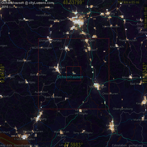
Analysis of Ochsenhausen night lights 2016
Square area 10x10 km:
 0%
0%90-99
0%80-89
0%70-79
0%60-69
0%50-59
0%40-49
2.27%30-39
0.57%20-29
0.28%10-19
0%0-9
96.88%Square area 50x50 km:
0.37%90-99
0.45%80-89
0.31%70-79
0.27%60-69
0.33%50-59
0.34%40-49
0.59%30-39
0.49%20-29
0.45%10-19
1.13%0-9
95.27%Clear (daylight) street map image can be seen on geolist.org.
Map coordinates:
48° 32' 16.8" North, 9° 14' 49.8" East
48° 4' 13" North, 9° 57' 1.1" East
47° 35' 53.9" North, 10° 39' 12.3" East
Some cities around Ochsenhausen sort by population:
• Memmingen
19.9 km =12.4 mi,  118°
118°
• Biberach an der Riß
12.1 km =7.5 mi,  282°
282°
• Bad Waldsee
22.1 km =13.7 mi,  221°
221°
• Laupheim
18.3 km =11.4 mi,  343°
343°
• Illertissen
20.5 km =12.7 mi,  33°
33°
• Bad Wurzach
18.5 km =11.5 mi,  192°
192°
• Dietenheim
18 km =11.2 mi, 29°
• Schwendi
11.7 km =7.3 mi,  9°
9°
2858326 (p: 8,950)
Sources (retrieved 2019-11-25):
» Earth at Night: Flat Maps 2012, 2016