Neuhof night lights from space
Night Light of Neuhof (Hesse) from space (Germany) Src. Average luminocity for 10x10km area is 3.1975% and for 50x50km: 1.7528%.
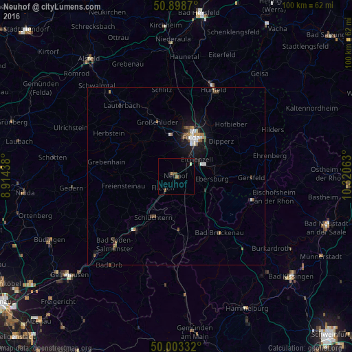
Analysis of Neuhof night lights 2016
Square area 10x10 km:
 0%
0%90-99
0.56%80-89
0%70-79
0.56%60-69
0.28%50-59
1.68%40-49
0.84%30-39
0%20-29
0.56%10-19
0%0-9
95.52%Square area 50x50 km:
0.26%90-99
0.26%80-89
0.08%70-79
0.18%60-69
0.22%50-59
0.35%40-49
0.31%30-39
0.12%20-29
0.36%10-19
1.44%0-9
96.42%Clear (daylight) street map image can be seen on geolist.org.
Map coordinates:
50° 53' 55.3" North, 8° 54' 51.8" East
50° 27' 11.3" North, 9° 37' 3" East
50° 0' 12" North, 10° 19' 14.3" East
Some cities around Neuhof sort by population:
• Fulda
11.7 km =7.3 mi,  20°
20°
• Schlüchtern
13.3 km =8.3 mi,  209°
209°
• Künzell
12.4 km =7.7 mi,  35°
35°
• Steinau an der Straße
18.9 km =11.7 mi,  215°
215°
• Eichenzell
7.3 km =4.5 mi,  50°
50°
• Flieden
4.9 km =3 mi,  227°
227°
• Großenlüder
16.4 km =10.2 mi,  341°
341°
• Grebenhain
20.1 km =12.5 mi,  281°
281°
2864936 (p: 11,422)
Sources (retrieved 2019-11-25):
» Earth at Night: Flat Maps 2012, 2016