Neufahrn bei Freising night lights from space
Night Light of Neufahrn bei Freising (Bavaria) from space (Germany) Src. Average luminocity for 10x10km area is 16.0952% and for 50x50km: 17.7047%.
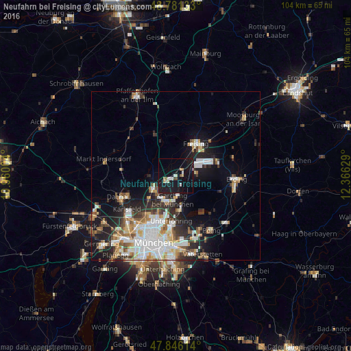
Analysis of Neufahrn bei Freising night lights 2016
Square area 10x10 km:
 2.7%
2.7%90-99
1.28%80-89
2.27%70-79
0.28%60-69
0.85%50-59
1.56%40-49
1.14%30-39
0.14%20-29
1.14%10-19
36.51%0-9
52.13%Square area 50x50 km:
4.06%90-99
3.95%80-89
1.74%70-79
1.76%60-69
1.79%50-59
1.93%40-49
1.78%30-39
2.13%20-29
4.48%10-19
8.92%0-9
67.46%Clear (daylight) street map image can be seen on geolist.org.
Map coordinates:
48° 46' 52.8" North, 10° 57' 36.1" East
48° 18' 57.2" North, 11° 39' 47.4" East
47° 50' 46.1" North, 12° 21' 58.6" East
Some cities around Neufahrn bei Freising sort by population:
• Freising
11.6 km =7.2 mi,  32°
32°
• Unterschleißheim
7.5 km =4.7 mi,  238°
238°
• Garching bei München
7.5 km =4.7 mi,  186°
186°
• Ismaning
9.3 km =5.8 mi,  170°
170°
• Eching
3.9 km =2.4 mi, 242°
• Oberschleißheim
10.2 km =6.3 mi,  224°
224°
• Hallbergmoos
6.7 km =4.2 mi,  78°
78°
• Oberding
13.8 km =8.6 mi,  89°
89°
2865376 (p: 18,255)
Sources (retrieved 2019-11-25):
» Earth at Night: Flat Maps 2012, 2016