Ingelfingen night lights from space
Night Light of Ingelfingen (Baden-Württemberg) from space (Germany) Src. Average luminocity for 10x10km area is 1.6283% and for 50x50km: 1.719%.
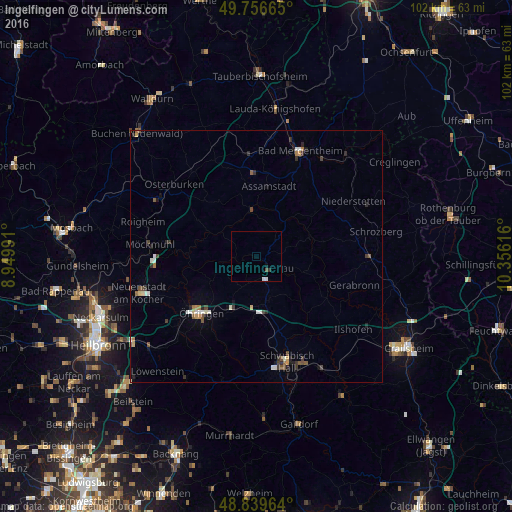
Analysis of Ingelfingen night lights 2016
Square area 10x10 km:
 0%
0%90-99
1.07%80-89
0%70-79
0%60-69
0%50-59
0%40-49
0.53%30-39
0.27%20-29
0.27%10-19
0%0-9
97.86%Square area 50x50 km:
0.22%90-99
0.26%80-89
0.16%70-79
0.13%60-69
0.17%50-59
0.23%40-49
0.34%30-39
0.37%20-29
0.36%10-19
0.35%0-9
97.41%Clear (daylight) street map image can be seen on geolist.org.
Map coordinates:
49° 45' 23.9" North, 8° 56' 59.7" East
49° 18' 1" North, 9° 39' 10.9" East
48° 50' 22.7" North, 10° 21' 22.2" East
Some cities around Ingelfingen sort by population:
• Öhringen
15.5 km =9.6 mi,  223°
223°
• Künzelsau
3 km =1.9 mi,  132°
132°
• Bretzfeld
20.6 km =12.8 mi,  229°
229°
• Pfedelbach
17.3 km =10.7 mi, 218°
• Boxberg
20 km =12.4 mi,  357°
357°
• Neuenstein
11.9 km =7.4 mi,  206°
206°
• Kupferzell
8.5 km =5.3 mi,  161°
161°
• Forchtenberg
6.8 km =4.2 mi,  259°
259°
2896021 (p: 5,914)
Sources (retrieved 2019-11-25):
» Earth at Night: Flat Maps 2012, 2016