Münsingen night lights from space
Night Light of Münsingen (Baden-Württemberg) from space (Germany) Src. Average luminocity for 10x10km area is 2.9716% and for 50x50km: 4.749%.
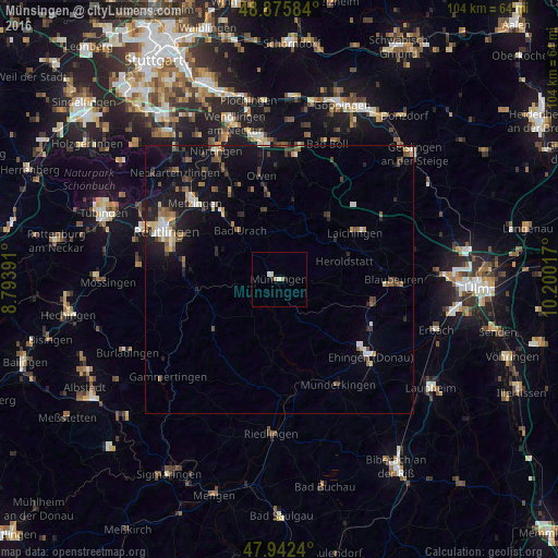
Analysis of Münsingen night lights 2016
Square area 10x10 km:
 0.14%
0.14%90-99
1.56%80-89
0%70-79
0.43%60-69
0.71%50-59
0%40-49
0%30-39
0%20-29
0.57%10-19
0.57%0-9
96.02%Square area 50x50 km:
0.38%90-99
0.62%80-89
0.38%70-79
0.38%60-69
0.72%50-59
0.83%40-49
0.63%30-39
0.78%20-29
1.1%10-19
4.95%0-9
89.23%Clear (daylight) street map image can be seen on geolist.org.
Map coordinates:
48° 52' 33" North, 8° 47' 38.1" East
48° 24' 40.5" North, 9° 29' 49.3" East
47° 56' 32.6" North, 10° 12' 0.6" East
Some cities around Münsingen sort by population:
• Altes Lager
3 km =1.9 mi,  76°
76°
• Bad Urach
11.4 km =7.1 mi,  321°
321°
• Laichingen
16.4 km =10.2 mi,  58°
58°
• Dettingen an der Erms
17.4 km =10.8 mi, 319°
• Unterhausen
18 km =11.2 mi,  276°
276°
• Lenningen
15.6 km =9.7 mi,  354°
354°
• Schelklingen
17.8 km =11.1 mi,  102°
102°
• Sankt Johann
12.3 km =7.6 mi,  292°
292°
2867560 (p: 14,479)
Sources (retrieved 2019-11-25):
» Earth at Night: Flat Maps 2012, 2016