Schliengen night lights from space
Night Light of Schliengen (Baden-Württemberg) from space (Germany) Src. Average luminocity for 10x10km area is 9.4673% and for 50x50km: 18.0118%.
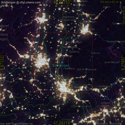
Analysis of Schliengen night lights 2016
Square area 10x10 km:
 1.04%
1.04%90-99
0.15%80-89
0.6%70-79
1.79%60-69
0.74%50-59
2.83%40-49
0.6%30-39
1.34%20-29
1.64%10-19
10.27%0-9
79.02%Square area 50x50 km:
3.36%90-99
2.9%80-89
1.24%70-79
1.7%60-69
1.79%50-59
2.75%40-49
2.65%30-39
3.01%20-29
5.11%10-19
12.36%0-9
63.13%Clear (daylight) street map image can be seen on geolist.org.
Map coordinates:
48° 13' 39.1" North, 6° 52' 24" East
47° 45' 25.1" North, 7° 34' 35.2" East
47° 16' 55.7" North, 8° 16' 46.5" East
Some cities around Schliengen sort by population:
• Müllheim
7 km =4.3 mi,  35°
35°
• Rixheim, FR
13.1 km =8.1 mi,  266°
266°
• Riedisheim, FR
15.7 km =9.8 mi, 266°
• Neuenburg am Rhein
6.5 km =4 mi,  349°
349°
• Efringen-Kirchen
11.9 km =7.4 mi,  183°
183°
• Kandern
8 km =5 mi,  126°
126°
• Sausheim, FR
15.6 km =9.7 mi,  282°
282°
• Heitersheim
14.4 km =8.9 mi,  24°
24°
2838534 (p: 5,208)
Sources (retrieved 2019-11-25):
» Earth at Night: Flat Maps 2012, 2016