Mittenwald night lights from space
Night Light of Mittenwald (Bavaria) from space (Germany) Src. Average luminocity for 10x10km area is 0.8239% and for 50x50km: 4.1968%.
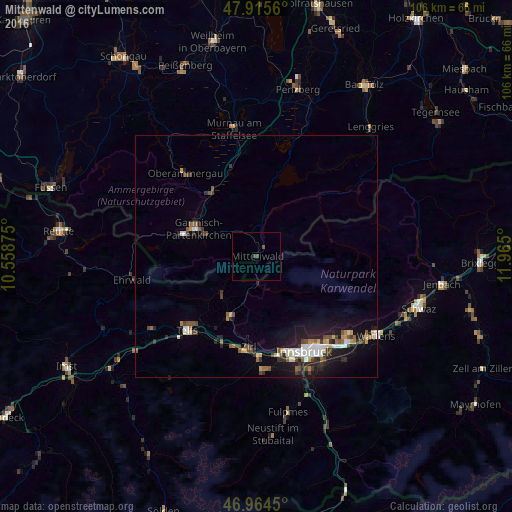
Analysis of Mittenwald night lights 2016
Square area 10x10 km:
 0%
0%90-99
0%80-89
0%70-79
0%60-69
0%50-59
0.43%40-49
0.99%30-39
0.28%20-29
0%10-19
0%0-9
98.3%Square area 50x50 km:
0.58%90-99
0.68%80-89
0.28%70-79
0.4%60-69
0.37%50-59
0.68%40-49
0.68%30-39
0.71%20-29
1.12%10-19
3.34%0-9
91.16%Clear (daylight) street map image can be seen on geolist.org.
Map coordinates:
47° 54' 56.2" North, 10° 33' 31.5" East
47° 26' 31.9" North, 11° 15' 42.7" East
46° 57' 52.2" North, 11° 57' 54" East
Some cities around Mittenwald sort by population:
• Innsbruck, AT
22.3 km =13.9 mi,  153°
153°
• Hötting, AT
21 km =13 mi,  157°
157°
• Garmisch-Partenkirchen
13.7 km =8.5 mi,  293°
293°
• Telfs, AT
20.9 km =13 mi,  224°
224°
• Arzl, AT
21.9 km =13.6 mi,  143°
143°
• Zirl, AT
18.8 km =11.7 mi,  185°
185°
• Völs, AT
22 km =13.7 mi,  165°
165°
• Mühlau, AT
20.5 km =12.7 mi, 149°
2870482 (p: 7,996)
Sources (retrieved 2019-11-25):
» Earth at Night: Flat Maps 2012, 2016