Lotte night lights from space
Night Light of Lotte (North Rhine-Westphalia) from space (Germany) Src. Average luminocity for 10x10km area is 7.0354% and for 50x50km: 4.5788%.
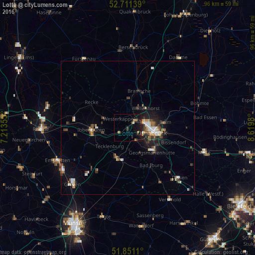
Analysis of Lotte night lights 2016
Square area 10x10 km:
 0%
0%90-99
0.51%80-89
0.38%70-79
0.63%60-69
2.02%50-59
1.26%40-49
0%30-39
2.02%20-29
0.51%10-19
11.11%0-9
81.57%Square area 50x50 km:
0.55%90-99
0.69%80-89
0.34%70-79
0.45%60-69
0.63%50-59
0.67%40-49
0.7%30-39
0.87%20-29
1.05%10-19
2.88%0-9
91.16%Clear (daylight) street map image can be seen on geolist.org.
Map coordinates:
52° 42' 41" North, 7° 12' 48.8" East
52° 16' 60" North, 7° 55' 0" East
51° 51' 4" North, 8° 37' 11.3" East
Some cities around Lotte sort by population:
• Osnabrück
9.1 km =5.7 mi,  97°
97°
• Wallenhorst
10.1 km =6.3 mi,  42°
42°
• Lengerich
11.4 km =7.1 mi,  199°
199°
• Hagen
10.6 km =6.6 mi,  155°
155°
• Mettingen
9.8 km =6.1 mi,  292°
292°
• Westerkappeln
4.3 km =2.7 mi,  328°
328°
• Hasbergen
5.9 km =3.7 mi,  149°
149°
• Tecklenburg
10 km =6.2 mi,  224°
224°
2875760 (p: 13,580)
Sources (retrieved 2019-11-25):
» Earth at Night: Flat Maps 2012, 2016