Lohr am Main night lights from space
Night Light of Lohr am Main (Bavaria) from space (Germany) Src. Average luminocity for 10x10km area is 5.2647% and for 50x50km: 1.8225%.
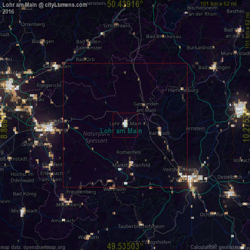
Analysis of Lohr am Main night lights 2016
Square area 10x10 km:
 0.84%
0.84%90-99
1.54%80-89
1.54%70-79
0%60-69
0%50-59
0%40-49
0.56%30-39
0.42%20-29
0.56%10-19
0.14%0-9
94.4%Square area 50x50 km:
0.16%90-99
0.26%80-89
0.17%70-79
0.12%60-69
0.26%50-59
0.25%40-49
0.47%30-39
0.36%20-29
0.46%10-19
0.79%0-9
96.7%Clear (daylight) street map image can be seen on geolist.org.
Map coordinates:
50° 26' 21" North, 8° 52' 8.8" East
49° 59' 21.2" North, 9° 34' 20" East
49° 32' 6.1" North, 10° 16' 31.3" East
Some cities around Lohr am Main sort by population:
• Wertheim
26 km =16.2 mi,  190°
190°
• Karlstadt
14.7 km =9.1 mi,  102°
102°
• Hösbach
26.1 km =16.2 mi,  274°
274°
• Gemünden am Main
11.7 km =7.3 mi,  54°
54°
• Marktheidenfeld
16.1 km =10 mi,  172°
172°
• Haibach
26.2 km =16.3 mi,  263°
263°
• Zellingen
20.3 km =12.6 mi,  120°
120°
• Laufach
19.7 km =12.2 mi,  278°
278°
2876147 (p: 16,127)
Sources (retrieved 2019-11-25):
» Earth at Night: Flat Maps 2012, 2016