Gemünden am Main night lights from space
Night Light of Gemünden am Main (Bavaria) from space (Germany) Src. Average luminocity for 10x10km area is 0.9454% and for 50x50km: 1.2231%.
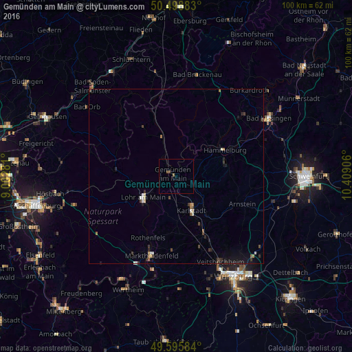
Analysis of Gemünden am Main night lights 2016
Square area 10x10 km:
 0%
0%90-99
0%80-89
0%70-79
0%60-69
0%50-59
1.12%40-49
0.56%30-39
0%20-29
0%10-19
0%0-9
98.32%Square area 50x50 km:
0.09%90-99
0.17%80-89
0.1%70-79
0.04%60-69
0.18%50-59
0.15%40-49
0.28%30-39
0.31%20-29
0.2%10-19
0.82%0-9
97.66%Clear (daylight) street map image can be seen on geolist.org.
Map coordinates:
50° 29' 55.8" North, 9° 0' 10.1" East
50° 2' 58.1" North, 9° 42' 21.3" East
49° 35' 45" North, 10° 24' 32.6" East
Some cities around Gemünden am Main sort by population:
• Lohr am Main
11.7 km =7.3 mi,  234°
234°
• Karlstadt
11 km =6.8 mi,  154°
154°
• Hammelburg
15.2 km =9.4 mi,  60°
60°
• Marktheidenfeld
23.8 km =14.8 mi,  197°
197°
• Veitshöchheim
27.2 km =16.9 mi, 152°
• Arnstein
20.5 km =12.7 mi,  112°
112°
• Zellingen
18.7 km =11.6 mi, 154°
• Oberthulba
24.5 km =15.2 mi,  47°
47°
2921379 (p: 11,375)
Sources (retrieved 2019-11-25):
» Earth at Night: Flat Maps 2012, 2016