Jüterbog night lights from space
Night Light of Jüterbog (Brandenburg) from space (Germany) Src. Average luminocity for 10x10km area is 2.9975% and for 50x50km: 0.7455%.
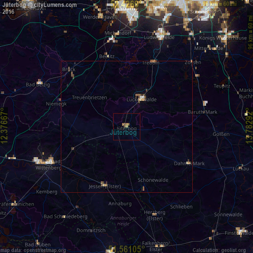
Analysis of Jüterbog night lights 2016
Square area 10x10 km:
 0%
0%90-99
0%80-89
0%70-79
1.14%60-69
1.89%50-59
0%40-49
1.01%30-39
0%20-29
0%10-19
0%0-9
95.96%Square area 50x50 km:
0.02%90-99
0.06%80-89
0.06%70-79
0.14%60-69
0.21%50-59
0.15%40-49
0.23%30-39
0.17%20-29
0.09%10-19
0.04%0-9
98.84%Clear (daylight) street map image can be seen on geolist.org.
Map coordinates:
52° 25' 36.8" North, 12° 22' 36" East
51° 59' 45.9" North, 13° 4' 47.2" East
51° 33' 39.8" North, 13° 46' 58.5" East
Some cities around Jüterbog sort by population:
• Luckenwalde
12.1 km =7.5 mi,  29°
29°
• Beelitz
27.9 km =17.3 mi,  344°
344°
• Jessen
24 km =14.9 mi,  200°
200°
• Trebbin
26.5 km =16.5 mi,  22°
22°
• Treuenbrietzen
18.1 km =11.2 mi,  308°
308°
• Friedrichstadt
30.6 km =19 mi,  246°
246°
• Niedergörsdorf
6.7 km =4.2 mi, 254°
• Dahme
27.6 km =17.1 mi,  120°
120°
2894394 (p: 13,292)
Sources (retrieved 2019-11-25):
» Earth at Night: Flat Maps 2012, 2016