Hofgeismar night lights from space
Night Light of Hofgeismar (Hesse) from space (Germany) Src. Average luminocity for 10x10km area is 2.2794% and for 50x50km: 3.6888%.
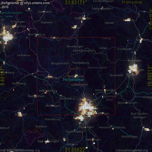
Analysis of Hofgeismar night lights 2016
Square area 10x10 km:
 0%
0%90-99
0%80-89
0%70-79
1.6%60-69
0%50-59
0.67%40-49
0.4%30-39
0%20-29
0.53%10-19
0.53%0-9
96.26%Square area 50x50 km:
0.6%90-99
0.85%80-89
0.26%70-79
0.53%60-69
0.49%50-59
0.55%40-49
0.47%30-39
0.45%20-29
0.88%10-19
1.81%0-9
93.1%Clear (daylight) street map image can be seen on geolist.org.
Map coordinates:
51° 55' 54.2" North, 8° 40' 54.7" East
51° 29' 45.9" North, 9° 23' 6" East
51° 3' 22.4" North, 10° 5' 17.3" East
Some cities around Hofgeismar sort by population:
• Warburg
16.5 km =10.3 mi,  267°
267°
• Vellmar
16.7 km =10.4 mi,  156°
156°
• Borgentreich
12.8 km =8 mi,  309°
309°
• Calden
9.7 km =6 mi,  173°
173°
• Immenhausen
10.1 km =6.3 mi,  139°
139°
• Zierenberg
15.2 km =9.4 mi,  202°
202°
• Grebenstein
5.8 km =3.6 mi, 160°
• Trendelburg
9 km =5.6 mi,  15°
15°
2902559 (p: 16,444)
Sources (retrieved 2019-11-25):
» Earth at Night: Flat Maps 2012, 2016