Harsefeld night lights from space
Night Light of Harsefeld (Lower Saxony) from space (Germany) Src. Average luminocity for 10x10km area is 1.041% and for 50x50km: 5.0372%.
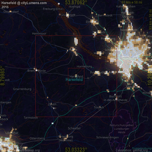
Analysis of Harsefeld night lights 2016
Square area 10x10 km:
 0%
0%90-99
0%80-89
0%70-79
0%60-69
0%50-59
0.66%40-49
1.19%30-39
0.26%20-29
0%10-19
0%0-9
97.88%Square area 50x50 km:
0.68%90-99
0.92%80-89
0.5%70-79
0.62%60-69
0.74%50-59
0.54%40-49
0.62%30-39
0.52%20-29
1.14%10-19
3.48%0-9
90.24%Clear (daylight) street map image can be seen on geolist.org.
Map coordinates:
53° 52' 14.2" North, 8° 47' 59.5" East
53° 27' 14.4" North, 9° 30' 10.7" East
53° 1' 59.6" North, 10° 12' 22" East
Some cities around Harsefeld sort by population:
• Stade
15.6 km =9.7 mi,  353°
353°
• Buxtehude
12.2 km =7.6 mi,  83°
83°
• Wedel
19.4 km =12.1 mi,  41°
41°
• Neu Wulmstorf
19.7 km =12.2 mi,  85°
85°
• Jork
14.6 km =9.1 mi,  53°
53°
• Horneburg
7.6 km =4.7 mi, 39°
• Sittensen
19.8 km =12.3 mi,  179°
179°
• Ahlerstedt
7 km =4.3 mi,  210°
210°
2910280 (p: 12,350)
Sources (retrieved 2019-11-25):
» Earth at Night: Flat Maps 2012, 2016