Gschwend night lights from space
Night Light of Gschwend (Baden-Württemberg) from space (Germany) Src. Average luminocity for 10x10km area is 0.0142% and for 50x50km: 5.5816%.
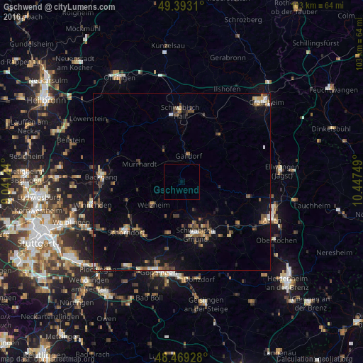
Analysis of Gschwend night lights 2016
Square area 10x10 km:
 0%
0%90-99
0%80-89
0%70-79
0%60-69
0%50-59
0%40-49
0%30-39
0%20-29
0%10-19
0%0-9
100%Square area 50x50 km:
0.39%90-99
0.5%80-89
0.43%70-79
0.71%60-69
0.75%50-59
1.02%40-49
1.19%30-39
0.88%20-29
0.97%10-19
3.94%0-9
89.24%Clear (daylight) street map image can be seen on geolist.org.
Map coordinates:
49° 23' 35.2" North, 9° 2' 28.5" East
48° 55' 60" North, 9° 44' 39.7" East
48° 28' 9.4" North, 10° 26' 51" East
Some cities around Gschwend sort by population:
• Schwäbisch Gmünd
15.4 km =9.6 mi,  165°
165°
• Murrhardt
13.8 km =8.6 mi,  293°
293°
• Gaildorf
7.7 km =4.8 mi,  13°
13°
• Rudersberg
16.6 km =10.3 mi,  251°
251°
• Lorch
15.5 km =9.6 mi,  194°
194°
• Welzheim
10.2 km =6.3 mi,  231°
231°
• Alfdorf
10.1 km =6.3 mi, 190°
• Mutlangen
12.6 km =7.8 mi,  162°
162°
2913972 (p: 5,092)
Sources (retrieved 2019-11-25):
» Earth at Night: Flat Maps 2012, 2016