Gaildorf night lights from space
Night Light of Gaildorf (Baden-Württemberg) from space (Germany) Src. Average luminocity for 10x10km area is 0.9836% and for 50x50km: 5.1165%.
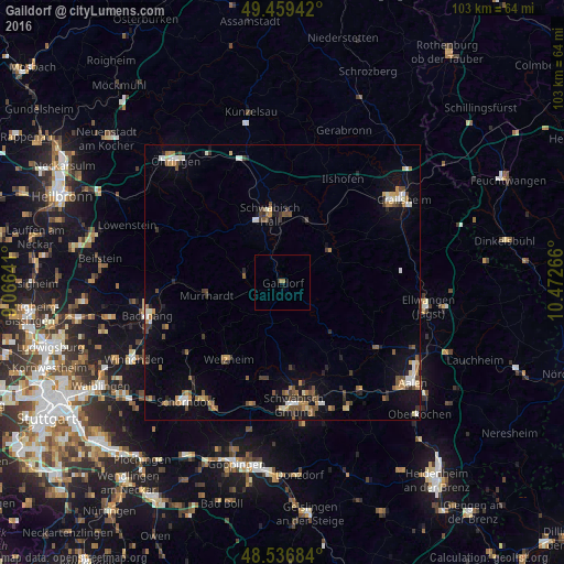
Analysis of Gaildorf night lights 2016
Square area 10x10 km:
 0%
0%90-99
0%80-89
0%70-79
0%60-69
1.04%50-59
0.15%40-49
0%30-39
0%20-29
0%10-19
0.6%0-9
98.21%Square area 50x50 km:
0.51%90-99
0.6%80-89
0.43%70-79
0.7%60-69
0.72%50-59
0.9%40-49
0.89%30-39
0.76%20-29
0.83%10-19
2.53%0-9
91.13%Clear (daylight) street map image can be seen on geolist.org.
Map coordinates:
49° 27' 33.9" North, 9° 3' 59.1" East
49° 0' 1" North, 9° 46' 10.3" East
48° 32' 12.6" North, 10° 28' 21.6" East
Some cities around Gaildorf sort by population:
• Schwäbisch Hall
12.5 km =7.8 mi,  349°
349°
• Murrhardt
14.7 km =9.1 mi,  261°
261°
• Welzheim
16.9 km =10.5 mi,  215°
215°
• Alfdorf
17.8 km =11.1 mi,  192°
192°
• Mutlangen
19.5 km =12.1 mi,  174°
174°
• Mainhardt
17.7 km =11 mi,  298°
298°
• Sulzbach an der Murr
19.6 km =12.2 mi,  270°
270°
• Gschwend
7.7 km =4.8 mi, 193°
2923325 (p: 12,571)
Sources (retrieved 2019-11-25):
» Earth at Night: Flat Maps 2012, 2016