Glandorf night lights from space
Night Light of Glandorf (Lower Saxony) from space (Germany) Src. Average luminocity for 10x10km area is 0.4008% and for 50x50km: 5.3469%.
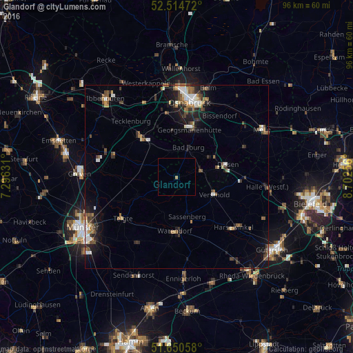
Analysis of Glandorf night lights 2016
Square area 10x10 km:
 0%
0%90-99
0%80-89
0%70-79
0%60-69
0.53%50-59
0%40-49
0%30-39
0%20-29
0%10-19
0%0-9
99.47%Square area 50x50 km:
0.64%90-99
0.83%80-89
0.41%70-79
0.45%60-69
0.85%50-59
0.78%40-49
1%30-39
0.97%20-29
1.25%10-19
3.15%0-9
89.65%Clear (daylight) street map image can be seen on geolist.org.
Map coordinates:
52° 30' 53" North, 7° 17' 46.7" East
52° 5' 5.1" North, 7° 59' 58" East
51° 39' 2.1" North, 8° 42' 9.2" East
Some cities around Glandorf sort by population:
• Versmold
11.6 km =7.2 mi,  115°
115°
• Sassenberg
10.7 km =6.6 mi,  164°
164°
• Bad Iburg
8.3 km =5.2 mi,  20°
20°
• Ostbevern
11.8 km =7.3 mi,  245°
245°
• Hilter
11.6 km =7.2 mi,  60°
60°
• Bad Laer
6 km =3.7 mi,  73°
73°
• Lienen
7.3 km =4.5 mi,  351°
351°
• Bad Rothenfelde
12 km =7.5 mi, 72°
2920205 (p: 6,867)
Sources (retrieved 2019-11-25):
» Earth at Night: Flat Maps 2012, 2016