Einhausen night lights from space
Night Light of Einhausen (Hesse) from space (Germany) Src. Average luminocity for 10x10km area is 22.1872% and for 50x50km: 17.7437%.
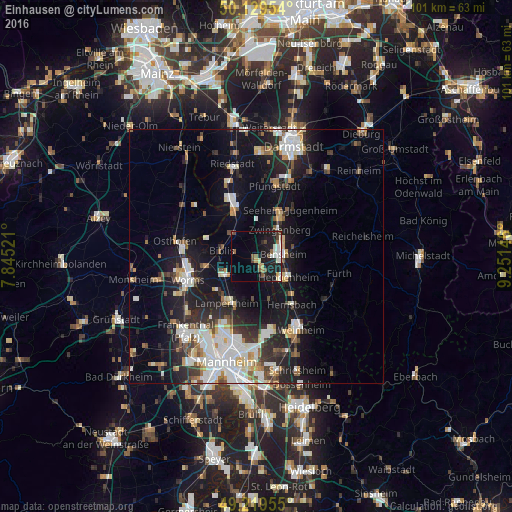
Analysis of Einhausen night lights 2016
Square area 10x10 km:
 3.21%
3.21%90-99
5.08%80-89
1.6%70-79
1.87%60-69
1.87%50-59
2.54%40-49
3.74%30-39
0.94%20-29
4.14%10-19
24.33%0-9
50.67%Square area 50x50 km:
3.65%90-99
4.03%80-89
1.26%70-79
1.59%60-69
1.64%50-59
1.68%40-49
1.77%30-39
2.14%20-29
5.18%10-19
13.83%0-9
63.22%Clear (daylight) street map image can be seen on geolist.org.
Map coordinates:
50° 7' 46.3" North, 7° 50' 42.8" East
49° 40' 36" North, 8° 32' 54" East
49° 13' 10.4" North, 9° 15' 5.3" East
Some cities around Einhausen sort by population:
• Bensheim
5.1 km =3.2 mi,  81°
81°
• Heppenheim an der Bergstrasse
7.2 km =4.5 mi,  123°
123°
• Bürstadt
7.4 km =4.6 mi,  239°
239°
• Lorsch
3.2 km =2 mi,  156°
156°
• Gernsheim
9.5 km =5.9 mi,  333°
333°
• Alsbach-Hähnlein
7.7 km =4.8 mi,  26°
26°
• Biblis
6.7 km =4.2 mi,  284°
284°
• Zwingenberg
6.9 km =4.3 mi,  40°
40°
2931753 (p: 5,933)
Sources (retrieved 2019-11-25):
» Earth at Night: Flat Maps 2012, 2016