Elsfleth night lights from space
Night Light of Elsfleth (Lower Saxony) from space (Germany) Src. Average luminocity for 10x10km area is 2.3157% and for 50x50km: 7.5338%.
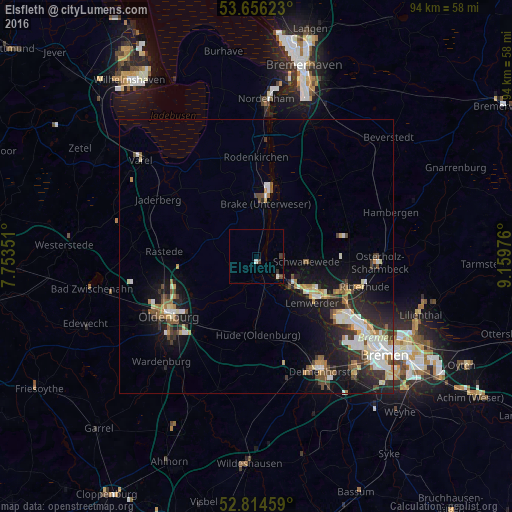
Analysis of Elsfleth night lights 2016
Square area 10x10 km:
 0.13%
0.13%90-99
0.88%80-89
0%70-79
0%60-69
0%50-59
0.13%40-49
1.52%30-39
0.63%20-29
0.25%10-19
0%0-9
96.46%Square area 50x50 km:
1.17%90-99
1.54%80-89
0.7%70-79
0.72%60-69
0.85%50-59
0.76%40-49
1.2%30-39
1.05%20-29
2.16%10-19
5.41%0-9
84.44%Clear (daylight) street map image can be seen on geolist.org.
Map coordinates:
53° 39' 22.4" North, 7° 45' 12.6" East
53° 14' 14.9" North, 8° 27' 23.9" East
52° 48' 52.5" North, 9° 9' 35.1" East
Some cities around Elsfleth sort by population:
• Vegesack
13.3 km =8.3 mi,  126°
126°
• Burglesum
17.4 km =10.8 mi,  117°
117°
• Rastede
17.1 km =10.6 mi,  274°
274°
• Schwanewede
9.6 km =6 mi,  92°
92°
• Brake (Unterweser)
10.8 km =6.7 mi,  9°
9°
• Hude
14.4 km =8.9 mi,  178°
178°
• Lemwerder
13.3 km =8.3 mi, 126°
• Ovelgönne
11.8 km =7.3 mi,  348°
348°
2930726 (p: 9,310)
Sources (retrieved 2019-11-25):
» Earth at Night: Flat Maps 2012, 2016