Dörentrup night lights from space
Night Light of Dörentrup (North Rhine-Westphalia) from space (Germany) Src. Average luminocity for 10x10km area is 0.048% and for 50x50km: 3.5583%.
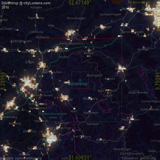
Analysis of Dörentrup night lights 2016
Square area 10x10 km:
 0%
0%90-99
0%80-89
0%70-79
0%60-69
0%50-59
0%40-49
0%30-39
0%20-29
0%10-19
0%0-9
100%Square area 50x50 km:
0.28%90-99
0.36%80-89
0.39%70-79
0.33%60-69
0.55%50-59
0.65%40-49
0.87%30-39
0.43%20-29
0.39%10-19
1.42%0-9
94.31%Clear (daylight) street map image can be seen on geolist.org.
Map coordinates:
52° 28' 17.4" North, 8° 17' 58.8" East
52° 2' 27.9" North, 9° 0' 10" East
51° 36' 23.4" North, 9° 42' 21.3" East
Some cities around Dörentrup sort by population:
• Detmold
14.4 km =8.9 mi,  217°
217°
• Lemgo
7.2 km =4.5 mi,  258°
258°
• Lage
15.3 km =9.5 mi,  249°
249°
• Rinteln
16.9 km =10.5 mi,  17°
17°
• Vlotho
16.9 km =10.5 mi,  324°
324°
• Blomberg
12.4 km =7.7 mi,  151°
151°
• Aerzen
17.5 km =10.9 mi,  86°
86°
• Barntrup
9.6 km =6 mi,  125°
125°
2936153 (p: 8,713)
Sources (retrieved 2019-11-25):
» Earth at Night: Flat Maps 2012, 2016