Aerzen night lights from space
Night Light of Aerzen (Lower Saxony) from space (Germany) Src. Average luminocity for 10x10km area is 0.8763% and for 50x50km: 1.6686%.
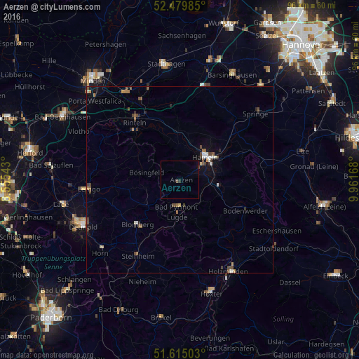
Analysis of Aerzen night lights 2016
Square area 10x10 km:
 0%
0%90-99
0%80-89
0%70-79
0%60-69
0%50-59
0%40-49
0.76%30-39
0.25%20-29
0.25%10-19
0.25%0-9
98.48%Square area 50x50 km:
0.16%90-99
0.21%80-89
0.12%70-79
0.14%60-69
0.28%50-59
0.27%40-49
0.47%30-39
0.21%20-29
0.22%10-19
0.62%0-9
97.31%Clear (daylight) street map image can be seen on geolist.org.
Map coordinates:
52° 28' 47.5" North, 8° 33' 19.5" East
52° 2' 58.3" North, 9° 15' 30.8" East
51° 36' 54.1" North, 9° 57' 42" East
Some cities around Aerzen sort by population:
• Hameln
9 km =5.6 mi,  47°
47°
• Rinteln
19.5 km =12.1 mi,  321°
321°
• Bad Pyrmont
7.1 km =4.4 mi,  183°
183°
• Hessisch Oldendorf
13.7 km =8.5 mi,  357°
357°
• Blomberg
16.5 km =10.3 mi,  224°
224°
• Lügde
10.2 km =6.3 mi, 184°
• Barntrup
11.7 km =7.3 mi,  235°
235°
• Dörentrup
17.5 km =10.9 mi,  266°
266°
2959374 (p: 10,755)
Sources (retrieved 2019-11-25):
» Earth at Night: Flat Maps 2012, 2016