Dietenhofen night lights from space
Night Light of Dietenhofen (Bavaria) from space (Germany) Src. Average luminocity for 10x10km area is 0.7848% and for 50x50km: 7.3362%.
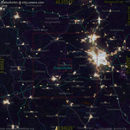
Analysis of Dietenhofen night lights 2016
Square area 10x10 km:
 0%
0%90-99
0%80-89
0%70-79
0.53%60-69
0%50-59
0%40-49
0%30-39
0%20-29
0.8%10-19
0.27%0-9
98.4%Square area 50x50 km:
1.31%90-99
1.13%80-89
0.77%70-79
0.75%60-69
0.98%50-59
1.13%40-49
1.2%30-39
1.13%20-29
2.25%10-19
3.22%0-9
86.13%Clear (daylight) street map image can be seen on geolist.org.
Map coordinates:
49° 51' 19.5" North, 9° 59' 11.8" East
49° 23' 59.9" North, 10° 41' 23.1" East
48° 56' 24.9" North, 11° 23' 34.4" East
Some cities around Dietenhofen sort by population:
• Ansbach
12.7 km =7.9 mi,  213°
213°
• Langenzenn
12.9 km =8 mi,  35°
35°
• Cadolzburg
13.4 km =8.3 mi,  61°
61°
• Heilsbronn
10.1 km =6.3 mi,  135°
135°
• Adelsdorf
7.8 km =4.8 mi,  357°
357°
• Markt Erlbach
10.8 km =6.7 mi,  345°
345°
• Petersaurach
11.9 km =7.4 mi,  158°
158°
• Wilhermsdorf
9.4 km =5.8 mi,  11°
11°
2937160 (p: 5,709)
Sources (retrieved 2019-11-25):
» Earth at Night: Flat Maps 2012, 2016