Altenberg night lights from space
Night Light of Altenberg (Saxony) from space (Germany) Src. Average luminocity for 10x10km area is 0.6737% and for 50x50km: 7.1713%.
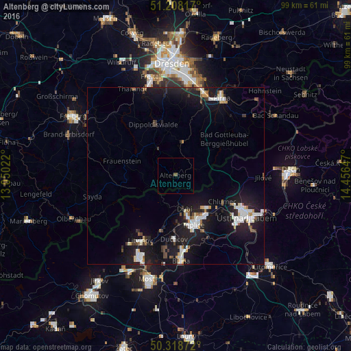
Analysis of Altenberg night lights 2016
Square area 10x10 km:
 0%
0%90-99
0%80-89
0%70-79
0%60-69
0%50-59
0.42%40-49
0.7%30-39
0%20-29
0%10-19
0%0-9
98.88%Square area 50x50 km:
1.42%90-99
1.31%80-89
0.52%70-79
0.43%60-69
0.42%50-59
0.64%40-49
0.62%30-39
0.72%20-29
2.12%10-19
9.17%0-9
82.64%Clear (daylight) street map image can be seen on geolist.org.
Map coordinates:
51° 12' 29.4" North, 13° 3' 0.8" East
50° 45' 56" North, 13° 45' 12" East
50° 19' 7.4" North, 14° 27' 23.3" East
Some cities around Altenberg sort by population:
• Ústí nad Labem, CZ
22.8 km =14.2 mi,  120°
120°
• Teplice, CZ
14.8 km =9.2 mi,  160°
160°
• Litvínov, CZ
20.3 km =12.6 mi,  207°
207°
• Krupka, CZ
11.6 km =7.2 mi,  140°
140°
• Dippoldiswalde
15.7 km =9.8 mi,  337°
337°
• Duchcov, CZ
18 km =11.2 mi,  181°
181°
• Dubí, CZ
9.2 km =5.7 mi,  165°
165°
• Dohna
22.4 km =13.9 mi,  19°
19°
2957834 (p: 5,167)
Sources (retrieved 2019-11-25):
» Earth at Night: Flat Maps 2012, 2016