Krupka night lights from space
Night Light of Krupka (Ústecký kraj) from space (Czech Republic) Src. Average luminocity for 10x10km area is 28.2781% and for 50x50km: 8.7801%.
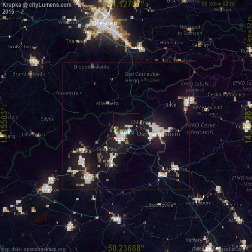
Analysis of Krupka night lights 2016
Square area 10x10 km:
 7.35%
7.35%90-99
7.22%80-89
1.34%70-79
2.01%60-69
4.14%50-59
2.14%40-49
0.94%30-39
1.2%20-29
6.82%10-19
22.46%0-9
44.39%Square area 50x50 km:
1.7%90-99
1.77%80-89
0.56%70-79
0.65%60-69
0.66%50-59
0.72%40-49
0.83%30-39
0.77%20-29
2.14%10-19
9.81%0-9
80.39%Clear (daylight) street map image can be seen on geolist.org.
Map coordinates:
51° 7' 40.3" North, 13° 9' 18.1" East
50° 41' 4.2" North, 13° 51' 29.3" East
50° 14' 12.8" North, 14° 33' 40.6" East
Some cities around Krupka sort by population:
• Ústí nad Labem
12.6 km =7.8 mi,  102°
102°
• Teplice
5.4 km =3.4 mi,  205°
205°
• Litvínov
19.1 km =11.9 mi,  242°
242°
• Bílina
16.2 km =10.1 mi,  201°
201°
• Bílina Kyselka
16.3 km =10.1 mi, 203°
• Duchcov
12 km =7.5 mi,  221°
221°
• Dubí
5.1 km =3.2 mi,  271°
271°
• Altenberg, DE
11.6 km =7.2 mi,  320°
320°
3072598 (p: 13,687)
Sources (retrieved 2019-11-25):
» Earth at Night: Flat Maps 2012, 2016