Třeboň night lights from space
Night Light of Třeboň (Jihočeský kraj) from space (Czech Republic) Src. Average luminocity for 10x10km area is 6.1443% and for 50x50km: 3.9944%.
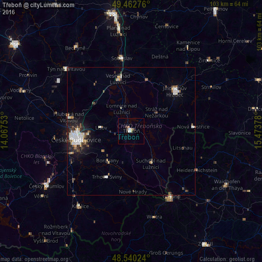
Analysis of Třeboň night lights 2016
Square area 10x10 km:
 1.19%
1.19%90-99
1.19%80-89
0.45%70-79
0.74%60-69
0.45%50-59
0.74%40-49
1.19%30-39
0.89%20-29
0.89%10-19
0%0-9
92.26%Square area 50x50 km:
0.78%90-99
0.76%80-89
0.33%70-79
0.32%60-69
0.31%50-59
0.6%40-49
0.45%30-39
0.68%20-29
0.96%10-19
2.01%0-9
92.8%Clear (daylight) street map image can be seen on geolist.org.
Map coordinates:
49° 27' 45.9" North, 14° 4' 3.1" East
49° 0' 13.1" North, 14° 46' 14.3" East
48° 32' 24.9" North, 15° 28' 25.6" East
Some cities around Třeboň sort by population:
• České Budějovice
21.9 km =13.6 mi,  261°
261°
• Jindřichův Hradec
23 km =14.3 mi,  47°
47°
• Český Krumlov
39.6 km =24.6 mi,  237°
237°
• Týn nad Vltavou
35.3 km =21.9 mi,  313°
313°
• Soběslav
28.7 km =17.8 mi,  352°
352°
• Kaplice
35.7 km =22.2 mi,  214°
214°
• Veselí nad Lužnicí
20.8 km =12.9 mi, 345°
• Bechyně
39.2 km =24.4 mi,  325°
325°
3064079 (p: 8,862)
Sources (retrieved 2019-11-25):
» Earth at Night: Flat Maps 2012, 2016