Šenov night lights from space
Night Light of Šenov (Moravskoslezský) from space (Czech Republic) Src. Average luminocity for 10x10km area is 40.0147% and for 50x50km: 18.7113%.
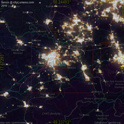
Analysis of Šenov night lights 2016
Square area 10x10 km:
 2.41%
2.41%90-99
5.35%80-89
5.35%70-79
6.42%60-69
7.09%50-59
6.28%40-49
6.95%30-39
8.82%20-29
20.45%10-19
27.94%0-9
2.94%Square area 50x50 km:
3.05%90-99
3.01%80-89
1.43%70-79
1.76%60-69
2.1%50-59
2.31%40-49
2.88%30-39
2.93%20-29
7.08%10-19
16.42%0-9
57.02%Clear (daylight) street map image can be seen on geolist.org.
Map coordinates:
50° 14' 41.7" North, 17° 40' 22.6" East
49° 47' 35.3" North, 18° 22' 33.9" East
49° 20' 13.6" North, 19° 4' 45.1" East
Some cities around Šenov sort by population:
• Ostrava
8.2 km =5.1 mi,  304°
304°
• Havířov
4.6 km =2.9 mi,  108°
108°
• Frýdek-Místek
12.4 km =7.7 mi,  188°
188°
• Orlová
7 km =4.3 mi,  33°
33°
• Bohumín
12.4 km =7.7 mi,  353°
353°
• Petřvald
4.3 km =2.7 mi,  12°
12°
• Rychvald
8.1 km =5 mi,  0°
0°
• Vratimov
5.4 km =3.4 mi,  241°
241°
3066184 (p: 5,462)
Sources (retrieved 2019-11-25):
» Earth at Night: Flat Maps 2012, 2016