Petřvald night lights from space
Night Light of Petřvald (Moravskoslezský) from space (Czech Republic) Src. Average luminocity for 10x10km area is 43.0334% and for 50x50km: 20.603%.
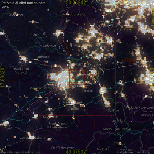
Analysis of Petřvald night lights 2016
Square area 10x10 km:
 2.54%
2.54%90-99
7.62%80-89
4.81%70-79
5.75%60-69
5.48%50-59
8.42%40-49
7.35%30-39
12.17%20-29
25.53%10-19
20.32%0-9
0%Square area 50x50 km:
3.28%90-99
3.31%80-89
1.53%70-79
1.97%60-69
2.41%50-59
2.7%40-49
3.43%30-39
3.25%20-29
8.39%10-19
16.93%0-9
52.81%Clear (daylight) street map image can be seen on geolist.org.
Map coordinates:
50° 16' 56.7" North, 17° 41' 10.6" East
49° 49' 51.6" North, 18° 23' 21.8" East
49° 22' 31.2" North, 19° 5' 33.1" East
Some cities around Petřvald sort by population:
• Ostrava
7.7 km =4.8 mi,  273°
273°
• Havířov
6.6 km =4.1 mi,  149°
149°
• Orlová
3.3 km =2.1 mi,  61°
61°
• Bohumín
8.4 km =5.2 mi,  344°
344°
• Starý Bohumín
10.3 km =6.4 mi, 338°
• Rychvald
4 km =2.5 mi,  346°
346°
• Vratimov
8.9 km =5.5 mi,  219°
219°
• Šenov
4.3 km =2.7 mi,  192°
192°
3068329 (p: 6,854)
Sources (retrieved 2019-11-25):
» Earth at Night: Flat Maps 2012, 2016