Planá night lights from space
Night Light of Planá (Plzeňský kraj) from space (Czech Republic) Src. Average luminocity for 10x10km area is 2.7233% and for 50x50km: 1.4763%.
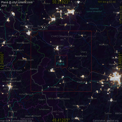
Analysis of Planá night lights 2016
Square area 10x10 km:
 0.27%
0.27%90-99
0.27%80-89
0.53%70-79
0%60-69
0%50-59
0%40-49
0.53%30-39
1.07%20-29
2.14%10-19
0%0-9
95.19%Square area 50x50 km:
0.26%90-99
0.29%80-89
0.1%70-79
0.06%60-69
0.18%50-59
0.26%40-49
0.17%30-39
0.18%20-29
0.26%10-19
0.07%0-9
98.16%Clear (daylight) street map image can be seen on geolist.org.
Map coordinates:
50° 19' 9.2" North, 12° 2' 26.4" East
49° 52' 5.4" North, 12° 44' 37.6" East
49° 24' 46.2" North, 13° 26' 48.9" East
Some cities around Planá sort by population:
• Cheb
35.4 km =22 mi,  311°
311°
• Mariánské Lázně
11.1 km =6.9 mi,  344°
344°
• Tachov
11.3 km =7 mi,  224°
224°
• Tirschenreuth, DE
29.6 km =18.4 mi,  273°
273°
• Stříbro
22.1 km =13.7 mi,  124°
124°
• Waldsassen, DE
34.8 km =21.6 mi,  295°
295°
• Horní Slavkov
30.4 km =18.9 mi,  8°
8°
• Kynšperk nad Ohří
31.8 km =19.8 mi,  331°
331°
3068246 (p: 5,450)
Sources (retrieved 2019-11-25):
» Earth at Night: Flat Maps 2012, 2016