Klášterec nad Ohří night lights from space
Night Light of Klášterec nad Ohří (Ústecký kraj) from space (Czech Republic) Src. Average luminocity for 10x10km area is 8.4818% and for 50x50km: 3.8167%.
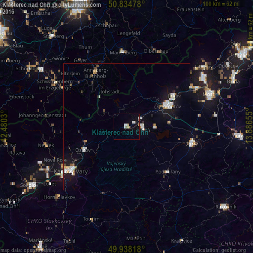
Analysis of Klášterec nad Ohří night lights 2016
Square area 10x10 km:
 2.24%
2.24%90-99
1.12%80-89
0.7%70-79
0.56%60-69
0.98%50-59
1.12%40-49
0.56%30-39
0%20-29
0%10-19
2.24%0-9
90.48%Square area 50x50 km:
0.84%90-99
0.74%80-89
0.28%70-79
0.23%60-69
0.35%50-59
0.28%40-49
0.29%30-39
0.3%20-29
0.31%10-19
3.22%0-9
93.17%Clear (daylight) street map image can be seen on geolist.org.
Map coordinates:
50° 50' 5.2" North, 12° 28' 49.1" East
50° 23' 19" North, 13° 11' 0.3" East
49° 56' 17.4" North, 13° 53' 11.6" East
Some cities around Klášterec nad Ohří sort by population:
• Karlovy Vary
28.1 km =17.5 mi,  231°
231°
• Chomutov
18.4 km =11.4 mi,  64°
64°
• Annaberg-Buchholz, DE
24.7 km =15.3 mi,  329°
329°
• Jirkov
22.4 km =13.9 mi, 56°
• Žatec
26.6 km =16.5 mi,  104°
104°
• Kadaň
5.9 km =3.7 mi, 95°
• Ostrov
19.6 km =12.2 mi,  242°
242°
• Podbořany
24 km =14.9 mi,  137°
137°
3073668 (p: 15,040)
Sources (retrieved 2019-11-25):
» Earth at Night: Flat Maps 2012, 2016