Benešov night lights from space
Night Light of Benešov (Central Bohemia) from space (Czech Republic) Src. Average luminocity for 10x10km area is 6.107% and for 50x50km: 4.2205%.
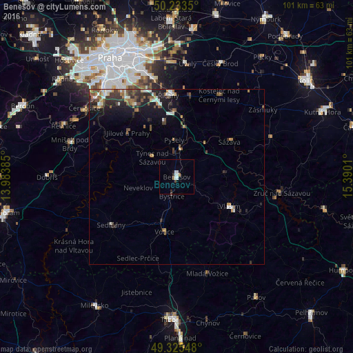
Analysis of Benešov night lights 2016
Square area 10x10 km:
 1.87%
1.87%90-99
1.34%80-89
0%70-79
0.4%60-69
0.67%50-59
0%40-49
0.8%30-39
0.53%20-29
0.53%10-19
0.53%0-9
93.32%Square area 50x50 km:
0.58%90-99
0.64%80-89
0.28%70-79
0.36%60-69
0.6%50-59
0.7%40-49
0.73%30-39
0.94%20-29
1.17%10-19
3.03%0-9
90.96%Clear (daylight) street map image can be seen on geolist.org.
Map coordinates:
50° 14' 0.6" North, 13° 59' 1.9" East
49° 46' 53.8" North, 14° 41' 13.1" East
49° 19' 31.7" North, 15° 23' 24.4" East
Some cities around Benešov sort by population:
• Modřany
32.3 km =20.1 mi,  322°
322°
• Černý Most
36.7 km =22.8 mi,  347°
347°
• Braník
34.2 km =21.3 mi,  325°
325°
• Vlašim
17.4 km =10.8 mi,  118°
118°
• Říčany
23.5 km =14.6 mi, 354°
• Sedlčany
23.1 km =14.4 mi,  234°
234°
• Český Brod
34.8 km =21.6 mi,  20°
20°
• Týnec nad Sázavou
9 km =5.6 mi,  309°
309°
3079508 (p: 16,257)
Sources (retrieved 2019-11-25):
» Earth at Night: Flat Maps 2012, 2016