Guayos night lights from space
Night Light of Guayos (Sancti Spíritus) from space (Cuba) Src. Average luminocity for 10x10km area is 15.371% and for 50x50km: 3.5064%.
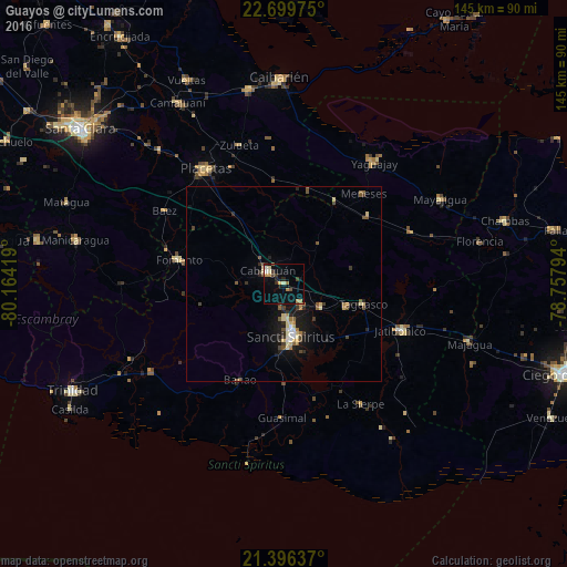
Analysis of Guayos night lights 2016
Square area 10x10 km:
 0%
0%90-99
1.98%80-89
2.98%70-79
3.77%60-69
1.59%50-59
0.99%40-49
2.38%30-39
1.98%20-29
1.98%10-19
5.75%0-9
76.59%Square area 50x50 km:
0.15%90-99
0.33%80-89
0.81%70-79
0.3%60-69
0.34%50-59
0.6%40-49
0.57%30-39
0.6%20-29
0.6%10-19
2.75%0-9
92.95%Clear (daylight) street map image can be seen on geolist.org.
Map coordinates:
22° 41' 59.1" North, 80° 9' 51.1" West
22° 2' 58.4" North, 79° 27' 39.8" West
21° 23' 46.9" North, 78° 45' 28.6" West
Some cities around Guayos sort by population:
• Sancti Spíritus
13.5 km =8.4 mi,  171°
171°
• Placetas
35.3 km =21.9 mi,  325°
325°
• Cabaiguán
4.9 km =3 mi,  311°
311°
• Yaguajay
38.6 km =24 mi,  36°
36°
• Fomento
27.5 km =17.1 mi,  282°
282°
• Jatibonico
32.3 km =20.1 mi,  111°
111°
• La Sierpe
36.7 km =22.8 mi,  147°
147°
• Zaza del Medio
11.3 km =7 mi,  120°
120°
3557432 (p: 15,000)
Sources (retrieved 2019-11-25):
» Earth at Night: Flat Maps 2012, 2016