Urrao night lights from space
Night Light of Urrao (Antioquia) from space (Colombia) Src. Average luminocity for 10x10km area is 3.7706% and for 50x50km: 0.7214%.
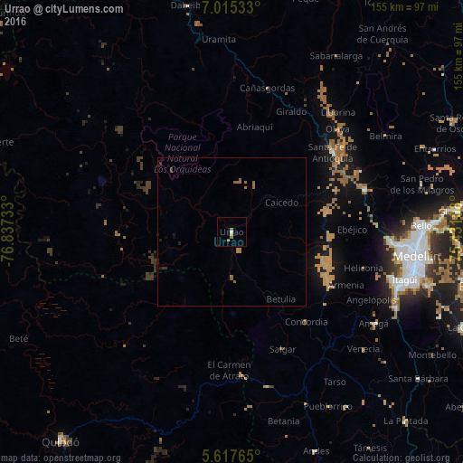
Analysis of Urrao night lights 2016
Square area 10x10 km:
 0%
0%90-99
0.87%80-89
0.87%70-79
0%60-69
2.6%50-59
0%40-49
0%30-39
0%20-29
0%10-19
0%0-9
95.67%Square area 50x50 km:
0%90-99
0.03%80-89
0.03%70-79
0.02%60-69
0.51%50-59
0.13%40-49
0.03%30-39
0.16%20-29
0.12%10-19
0.21%0-9
98.75%Clear (daylight) street map image can be seen on geolist.org.
Map coordinates:
7° 0' 55.2" North, 76° 50' 14.4" West
6° 19' 1.1" North, 76° 8' 3.1" West
5° 37' 3.5" North, 75° 25' 51.9" West
Some cities around Urrao sort by population:
• Ciudad Bolívar
52.9 km =32.9 mi,  166°
166°
• Amagá
56.7 km =35.2 mi,  122°
122°
• Santa Fe de Antioquia
43.1 km =26.8 mi,  51°
51°
• Concordia
39.2 km =24.4 mi,  140°
140°
• Frontino
50.5 km =31.4 mi,  0°
0°
• Salgar
43.4 km =27 mi,  154°
154°
• Cañasgordas
49.6 km =30.8 mi,  14°
14°
• Betulia
28.1 km =17.5 mi, 143°
3666395 (p: 18,846)
Sources (retrieved 2019-11-25):
» Earth at Night: Flat Maps 2012, 2016