Concordia night lights from space
Night Light of Concordia (Antioquia) from space (Colombia) Src. Average luminocity for 10x10km area is 1.4649% and for 50x50km: 3.1051%.
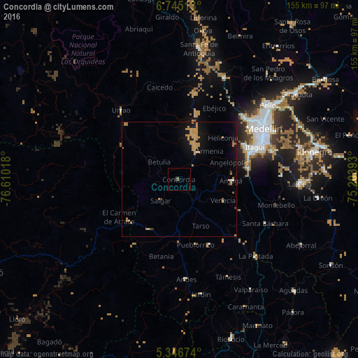
Analysis of Concordia night lights 2016
Square area 10x10 km:
 0%
0%90-99
0%80-89
0%70-79
0%60-69
0.83%50-59
0.83%40-49
0%30-39
0%20-29
1.45%10-19
0.21%0-9
96.69%Square area 50x50 km:
0.04%90-99
0.03%80-89
0.03%70-79
2.08%60-69
0.6%50-59
0.13%40-49
0.05%30-39
0.15%20-29
0.1%10-19
3.09%0-9
93.68%Clear (daylight) street map image can be seen on geolist.org.
Map coordinates:
6° 44' 42.5" North, 76° 36' 36.6" West
6° 2' 47" North, 75° 54' 25.4" West
5° 20' 48.3" North, 75° 12' 14.1" West
Some cities around Concordia sort by population:
• Caldas
30.4 km =18.9 mi,  80°
80°
• Ciudad Bolívar
25.1 km =15.6 mi,  211°
211°
• Amagá
22.6 km =14 mi,  91°
91°
• Fredonia
29.4 km =18.3 mi,  117°
117°
• Salgar
11.1 km =6.9 mi,  215°
215°
• Venecia
20.9 km =13 mi, 116°
• Pueblorrico
29.2 km =18.1 mi,  165°
165°
• Betulia
11.2 km =7 mi,  311°
311°
3686013 (p: 9,324)
Sources (retrieved 2019-11-25):
» Earth at Night: Flat Maps 2012, 2016