El Piñón night lights from space
Night Light of El Piñón (Magdalena) from space (Colombia) Src. Average luminocity for 10x10km area is 3.5248% and for 50x50km: 2.2337%.
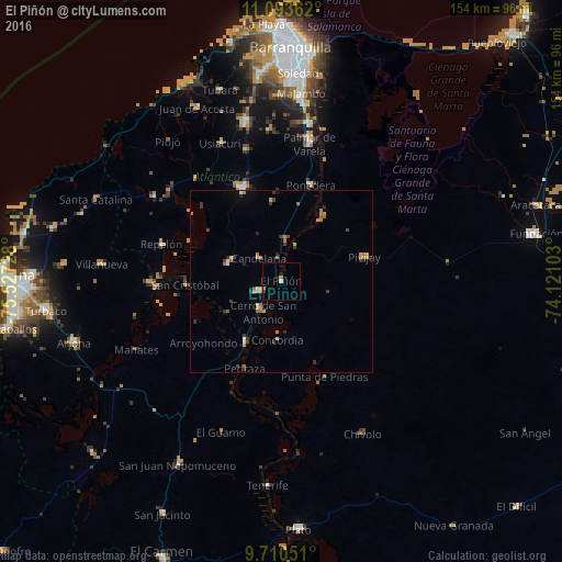
Analysis of El Piñón night lights 2016
Square area 10x10 km:
 0%
0%90-99
0.83%80-89
0%70-79
0.41%60-69
1.24%50-59
0%40-49
0%30-39
0.83%20-29
0%10-19
1.65%0-9
95.04%Square area 50x50 km:
0.04%90-99
0.3%80-89
0.13%70-79
0.44%60-69
0.72%50-59
0.18%40-49
0.18%30-39
0.63%20-29
0.43%10-19
0.27%0-9
96.69%Clear (daylight) street map image can be seen on geolist.org.
Map coordinates:
11° 5' 37" North, 75° 31' 38.2" West
10° 24' 10.2" North, 74° 49' 26.9" West
9° 42' 37.8" North, 74° 7' 15.7" West
Some cities around El Piñón sort by population:
• Campo de la Cruz
7.1 km =4.4 mi,  247°
247°
• Santa Lucía
17.3 km =10.7 mi,  239°
239°
• Manatí
15.5 km =9.6 mi,  288°
288°
• Candelaria
8.7 km =5.4 mi,  315°
315°
• Suan
9.8 km =6.1 mi,  218°
218°
• Calamar
19.5 km =12.1 mi,  210°
210°
• Cerro de San Antonio
9.9 km =6.2 mi, 209°
• Salamina
10.2 km =6.3 mi,  18°
18°
3683463 (p: 7,481)
Sources (retrieved 2019-11-25):
» Earth at Night: Flat Maps 2012, 2016