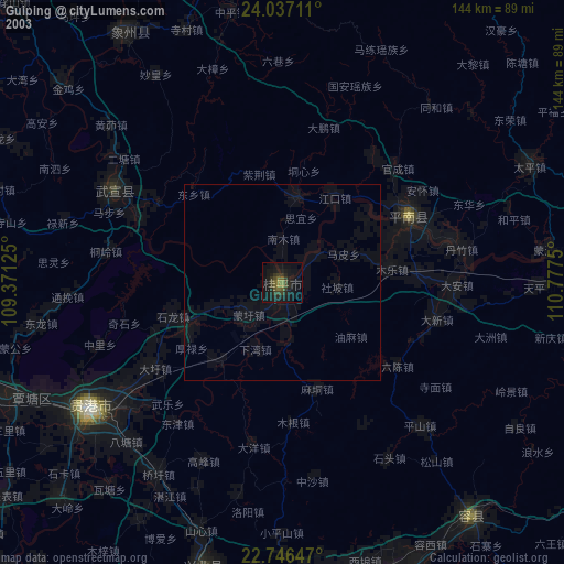
Guiping night lights from space
Night Light of Guiping (Guangxi) from space (China) Src. Average luminocity for 10x10km area is 30.7652% and for 50x50km: 2.4747%.


Analysis of Guiping night lights 2016
Square area 10x10 km:
 4.17%
4.17%90-99
5.68%80-89
3.22%70-79
3.6%60-69
4.36%50-59
3.41%40-49
4.17%30-39
4.55%20-29
4.73%10-19
39.02%0-9
23.11%Square area 50x50 km:
0.2%90-99
0.24%80-89
0.3%70-79
0.3%60-69
0.34%50-59
0.38%40-49
0.42%30-39
0.52%20-29
0.67%10-19
2.15%0-9
94.48%Clear (daylight) street map image can be seen on geolist.org.
Map coordinates:
24° 2' 13.6" North, 109° 22' 16.5" East
23° 23' 36.1" North, 110° 4' 27.7" East
22° 44' 47.3" North, 110° 46' 39" East
Some cities around Guiping sort by population:
• Yulin
84.9 km =52.8 mi,  174°
174°
• Guigang
57.9 km =36 mi,  235°
235°
• Luorong
122.1 km =75.9 mi,  337°
337°
• Pingnan
36.1 km =22.4 mi,  62°
62°
• Nandu
97.4 km =60.5 mi,  128°
128°
• Laibin
89.1 km =55.4 mi,  292°
292°
• Jinji
78.9 km =49 mi,  103°
103°
• Lingcheng
81.3 km =50.5 mi,  159°
159°
1809486 (p: 71,066)
Sources (retrieved 2019-11-25):
» NASA, Earths city lights 1995
» NASA city lights 2003
» Earth at Night: Flat Maps 2012, 2016