Zürich (Kreis 7) night lights from space
Night Light of Zürich (Kreis 7) (Zurich) from space (Switzerland) Src. Average luminocity for 10x10km area is 66.6429% and for 50x50km: 17.3209%.

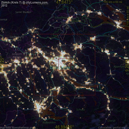
Analysis of Zürich (Kreis 7) night lights 2016
Square area 10x10 km:
 23.36%
90-99
18.3%80-89
4.76%70-79
3.57%60-69
4.91%50-59
7.74%40-49
8.18%30-39
10.71%20-29
13.1%10-19
5.36%0-9
0%Square area 50x50 km:
2.74%90-99
2.74%80-89
1.32%70-79
1.67%60-69
2.32%50-59
1.96%40-49
2.77%30-39
2.77%20-29
4.32%10-19
14.62%0-9
62.77%Clear (daylight) street map image can be seen on geolist.org.
Map coordinates:
47° 50' 50.3" North, 7° 52' 38.1" East
47° 22' 23.8" North, 8° 34' 49.4" East
46° 53' 41.9" North, 9° 17' 0.6" East
Some cities around Zürich (Kreis 7) sort by population:
• Zürich
2.4 km =1.5 mi,  252°
252°
• Dübendorf
3.9 km =2.4 mi,  47°
47°
• Wallisellen
4.8 km =3 mi,  14°
14°
• Küsnacht
6.1 km =3.8 mi,  177°
177°
• Kilchberg
6 km =3.7 mi,  205°
205°
• Dietlikon / Dietlikon (Dorf)
5.8 km =3.6 mi,  30°
30°
• Zollikon
3.7 km =2.3 mi,  187°
187°
• Wallisellen / Wallisellen-Ost
4.8 km =3 mi,  15°
15°
6295548 (p: 33,820)
Sources (retrieved 2019-11-25):
» Earth at Night: Flat Maps 2012, 2016